Thursday, March 20, 2008

US 20 in Massachusetts: Jacob’s Ladder Scenic Byway

In Massachusetts, the state where Route 20 has its beginning, there is a 33-mile stretch called “Jacob’s Ladder.” It was designated a Massachusetts scenic byway in 1992, and is located between the towns of Russell and Lee, Massachusetts. It represents the perfect picturesque view of small town New England, with the backdrop of the Berkshires.

The web site for National Scenic Byways describes the history of this trail:

“The Jacob's Ladder Trail originated centuries ago when people from the Mohican and Woronoake tribes walked between Connecticut and the Hudson River Valleys. The trail has now been transformed into one of the most beautiful roads in the United States. During 1910, authorities had the road built as the first highway specifically constructed for the new state-of-the-art horseless wagons, or automobiles. Adventurers from many places came to test themselves and their machines against the rugged terrain. At the time, there were potholes that could hide a tire, mud so deep it could bury a car, and small boulders blocking the road. Today, however, Jacob's Ladder Trail is a pleasant drive for motorists of a less venturesome sort. Many have appreciated the inspiring landscape of the Berkshire Hills while driving this relaxing route.

Not long after the road was built, it became known as the "Yellowstone Trail." This was because it joined with a highway that linked the Atlantic and Pacific Oceans together. The road stretched from Boston to Oregon. However, locals know this byway best as "The First of the Great Mountain Crossovers" because of the audacity and vision the engineers demonstrated by constructing this road over the wild mountains and through Jacob's Ladder Corridor.

In addition to sightseeing, visitors will find a lot of fun activities in the surrounding areas. Some of these include participating in the annual canoe race, visiting the abundant art and craft shops, or fishing some of the many lakes and streams. For those interested in the performing arts, dancers from all over the world converge at the annual Jacob's Pillow Dance Festival to put on many wonderful shows. Dancers from China, Russia, and other countries have expressed their fondness for this special community event.”


There are several web sites dedicated to this beautiful stretch of US Route 20:

Jacob’s Ladder Trail Scenic Byway This site explains what may be the history behind the name of the trail.

Jacob’s Ladder Scenic Byway

The Berkshire Web (Jacob’s Ladder Trail Page)


It sounds like a great drive in any season, rich in history and beautiful sights!


The US Route 20 Blog homepage can be found here.

Thursday, March 13, 2008

US 20 in Iowa & Illinois – Julien Dubuque Bridge


US Route 20 visits many large cities on its trek across the United States. One of them is Dubuque, Iowa, on the west side of the Mississippi River. Helping travelers to cross the Mississippi from East Dubuque, Illinois to Dubuque, Iowa on US 20 is the Julien Dubuque Bridge. The bridge is named after a French-Canadian pioneer, Julien Dubuque, who was the first permanent settler to this area.

This bridge was completed in 1943, and is a continuous steel arch truss bridge, with a span of 845 feet. There are two lanes of US 20, plus one pedestrian walkway.

There is a lot more traffic traveling in the area than there was when the bridge was first constructed. There have been discussions about the future of the bridge and what part it will play in moving traffic over the Mississippi. These discussion have included a range of ideas from expanding the bridge to four lanes to completely demolishing it and starting over with a bridge the looks similar. I’m all for preserving history whenever possible, but in light of the bridge collapse on I-35 in Minnesota which also crosses the Mississippi (but is of a different architectural design), I say safety should come first.
Julien Dubuque Bridge in the 1980s


The US Route 20 Blog homepage can be found here.

Monday, March 10, 2008

US 20 In NY: New York Times US 20 Road Trip

I thought you’d find this article, from the August 2006 New York Times, interesting. It’s called “On Route 20, Where the Past Is Present” and talks about a road trip on US 20 in New York. Enjoy!


Road Trip
On Route 20, Where the Past Is Present
By TRACIE ROZHON
Published: August 11, 2006
AMID high grass, sky-blue chicory and hollyhocks the color of strawberry syrup, the old house was easy to miss, a blur of tobacco-hued walls along a once-prosperous highway in upstate New York.

Perhaps it was the house’s columns that caused me to make a U-turn, or maybe it was the strange texture that, seen at highway speed, resembled stacks and stacks of brown eggs with — wait — was that an inscription carved in the lintel above the door? Was that a “for sale” sign stuck in the lawn? Would this rare cobblestone house, so close to the road in Geneva, N.Y., be torn down for some surefire development designed to bring back the crowds?

Architectural history — and some of its mysteries — was unfolding on my road trip west along Route 20 and then 20A, its interesting southern loop, from Albany to East Aurora: from 18th-century mansions to 19th-century storefronts, from tourist cabins built in the Great Depression to drive-ins visited in doo-wop days.

When the New York State Thruway was built in the 1950’s, to the north of the old highway and roughly parallel, progress along Route 20 skidded to a halt. To historians, the road is like a highway set in aspic, with vignettes of architecture, some of which may not be around next year.

Route 20 is a visual encyclopedia of American building types, not only the many historic houses open to the public but also the beleaguered gems, like the one with the columns about four hours west of Albany — the inscription over the door read: “Thomas Barron,” and, underneath, the date 1846. (The price on the house and its 13 acres is $375,000; the real estate agent said most of its value lies in its commercial zoning.)

Then there are the farms: some well-to-do, with the sun glinting off neat metal roofs and with silos wearing paint as fresh as dew. Some are not so well off: with sagging barns and peeling paint, with faded lettering and rusty horse vans parked in overgrown front yards.

The 290-mile route is lined with antiques shops, bed-and-breakfasts and signposts to nearby gardens, caverns and spectacular waterfalls. Lakes lap the sides of the road in towns with evocative names — Geneva, Cazenovia, Skaneateles. Slowing down, I glimpsed suntanned teenagers diving from docks, grandmothers pushing strollers, and a restored mail boat taking on passengers for a tour of waterside villas and elaborate boathouses redolent of the Gilded Age.

“Route 20 developed with the automobile,” said Tania Werbizky, director of grant programs for the Preservation League of New York State. “The road represents the architecture of travel: early gas stations, tourist cabins and burger chains that pre-date McDonald’s — so much is virtually unchanged.” Not quite a year ago, 108 miles of Route 20, from Duanesburg to La Fayette, was designated a state scenic byway, an action prompted by local preservation groups. But the designation does not stop owners from tearing down their houses, nor farmers from abandoning their fields.

MILE 61: SHARON SPRINGS Before reaching this spa town, I whizzed by giant signs for Howe Caverns and the Iroquois Indian Museum, Landis Arboretum and Secret Caverns. If these don’t attract you, head for a cooling drink in Sharon Springs at the newly restored American Hotel, a rather Southern-looking white clapboard 1847 building with porches running clear across the facade on both floors.

The town’s old Main Street intersects Route 20, and it was there that I got the sense of what turned out to be a leitmotif for the trip: while a good chunk of Sharon Springs is restored, so much is not.

An irresistible cast-iron pavilion — with only the word “Magnesia” emblazoned across the top — was a mystery, sitting across the street from a hauntingly deserted grand hotel. It’s easy to drive up the cracked driveway to the old spa hotel, almost to the front door, and then stroll along the long, lazy veranda. The whole place is empty, yet there are no “No Trespassing” signs. The porch still has an old rocker on it. The name “The Adler” is painted in red on the white facade.

MILE 78: CHERRY VALLEY Take a spur of Route 20 — called the Historic Cherry Valley Turnpike — for about six miles from the main highway to see a distinctive marble Civil War monument with an eagle on top and a row of antique storefronts, including a general store with what looks like the original screen door, and a white-haired clerk who might have been in the supporting cast of “On Golden Pond.”

But Cherry Valley is not another Sturbridge Village, with its period costumes and recreated atmosphere. The town is only a few miles east of the Glimmerglass Opera and Otsego Lake; its Erin’s coffee shop is packed with weeklong locals and weekending Manhattanites.

At the northeast corner of the lake, a winding 15-minute drive west from Cherry Valley, stands Hyde Hall, a fine neo-Classical stone manor house from the early 19th century, notable for its elegant, nearly bare interiors and airy, verdant landscaping, with a very English view down the lake: a high, wide 10-mile scene framed by old trees, with few signs of civilization. “Sense and Sensibility” could have been filmed there; if you’ve grown sick of overstuffed house museums, this is the place for you.

MILE 123: BOUCKVILLE It’s a bit like Hudson, N.Y. — a Main Street of antiques shops — but without the attitude. (And, some might say, without the consistently high quality.) A destination for some, most of Bouckville’s several dozen stores are group shops, featuring an array of dealers selling stuff that seems to encompass every household object from the 1920’s through the 1960’s.

Bucking the trend, however, was the Depot, which had some Arts and Crafts-era frames and some early blue Staffordshire. There also was an 18th-century French hand-colored print, in the manner of the British caricaturist Thomas Rowlandson, that was very decorative, depicting a man selling crutches to an eager public. Encased in an early gilt frame, it was much more charming than it sounds — for $175.

MILE 139: CAZENOVIA Who could resist the name? Route 20 is Main Street here, a shopper’s kaleidoscope of antiques shops and clothing boutiques. No one knows why the fanciest house in town was named Lorenzo, but some speculate that it may have been because the original owner was a fan of Lorenzo de’ Medici.

The house, from 1807, is a finely proportioned three-story ocher-painted mansion — and the outbuildings shout to be copied in your own backyard — but the curators have chosen to rip out much of the old carpets and wallpaper and replace some with replicas in jarring colors.

A few miles to the north is Chittenango Falls, and a state park that charges $6 per carload (though it’s free if you go late enough in the day). What’s different about this particular falls is how close you can get: very, very close. Watch out!

MILE 166: SKANEATELES Of all the towns along Route 20, Skaneateles has the most visible of lakefronts from the main road, and because of it one of the most romantic Main Streets. Cazenovia and Skaneateles probably vie for the most beautiful downtown on Route 20 — both are not to be missed — but where else but in Skaneateles can one see teak-and-mahogany boats boarding passengers across a glowing green park?

The one-hour excursion on the Judge Ben Wiles featured commentary by the skipper: a deeply tanned and T-shirted middle-aged woman who knew all about L. C. Smith, the typewriter tycoon from Syracuse (Smith-Corona), who had a villa across the lake, as well as more modern, self-made palazzo-builders like Robert J. Congel, the founder of Pyramid Management Group, the mall developers, who built waterfront houses for himself and for members of his family.

His was more contemporary-looking, but one of his children had chosen a shingle-style Stanford White-ish confection that looked like it had been built yesterday — and probably had been. The shingles were still blond, not yet gray.

MILE 173: AUBURN Remember the name William H. Seward from your seventh-grade history class? If so, you may remember Seward’s Folly, which refers to his influential role as secretary of state in the purchase of Alaska in 1867. The city of Auburn has many things to recommend it, but consider three. First, visit the Seward house, a big yellow Federal house of brick, built in 1816 by Seward’s father-in-law, Judge Elijah Miller. It has the books — mostly law books and compilations of magazines — that Seward perused when he lived there, off and on for 50 years.

Then stop by the Willard Memorial Chapel, furnished from the floor to the stenciled, beamed ceilings — and of course, to the stained-glass windows — by Louis Comfort Tiffany.

Next is Fort Hill Cemetery. Partly because of the raking late afternoon light, the graveyard where Harriet Tubman (the great abolitionist and a protégée of Seward’s) is buried was a fantasy of aged marble and granite. The best monument of all is a tall (at least 30 feet high) obelisk of crisply cut stone with only this one tantalizing — and still unanswered — question finely chiseled into marble: “Who is there to mourn for Logan?”

MILE 193: GENEVA The town was a surprise. Take a quick trip to the Hobart and William Smith Colleges campus, which overlooks Seneca Lake, and while you’re in the neighborhood see some of the most beautiful houses west of Nantucket, long and low and stuccoed, with new striped canvas awnings, near statuesque mid-19th-century row houses painted pistachio green and little-girl pink. Absolutely everything is crisp and clean. The whole place looks scrubbed.

MILE 290: EAST AURORA When Elbert Hubbard settled in this village on Route 20A in 1894 — after selling his share of the profitable Larkin Soap Company of Buffalo — he and his first wife, Bertha, and their children built a house on a side street and, after a trip to England when he saw William Morris and his Kelmscott Press, Hubbard set up his own small print shop. A furniture concern, a metalworking shop and the Roycroft Inn followed

Hubbard and his second wife, Alice (he fathered a child with her years before he divorced his first wife), died when the Lusitania was sunk in 1915, and his son took over the inn. The Depression hit, the business faltered and one after another owner went bankrupt until the mid-1990’s, when the inn was saved from the wrecking ball. It is now run by a nonprofit corporation, with 22 suites and rooms, some displaying the aphorisms that made Hubbard a sage in his day.

Most seem a bit sappy now, like embroidered mottoes on scented pillows in cheap catalogs: “The love we give away is the only love we keep,” Hubbard said, and “We work to become, not to acquire.”

But there is one that seems apt for this trip along a faded, but utterly fascinating, road replete with architectural history.

If victory is, as Hubbard wrote, a matter of staying power, then Route 20 is a real winner.

EAST to west, start in Albany. From the west, Buffalo Niagara International Airport is half an hour’s drive south to East Aurora, N.Y.

In Cazenovia, Lorenzo State Historic Site, at 17 Rippleton Road, is open 10 a.m. to 4:30 p.m. Tuesday through Sunday from May 1 through the last Sunday in October. Admission: $5 (315-655-3200; www.lorenzony.org).

A vintage excursion boat, the Judge Ben Wiles, anchors within sight of the highway in Skaneateles and offers a guided one-hour tour of lakeside villas for $10 (800-545-4318). Across the street is the sprawling Sherwood Inn, 26 West Genesee Street, whose rooms are reasonable at around $170 a night (315-685-3405; www.thesherwoodinn.com).

The Seward House, at 33 South Street in Auburn, has expanded a good bit since William H. Seward’s father-in-law invited him to live there in 1824. Current hours are Tuesday through Saturday, 10 a.m. to 4 p.m., and Sunday 1 to 4 p.m. Admission is $6 (315-252-1283; www.sewardhouse.org).

At the Roycroft Inn, 40 South Grove Street, East Aurora, rooms start at about $90. (716-652-5552; www.roycroftinn.com).


The US Route 20 Blog homepage can be found here.

Tuesday, March 4, 2008

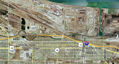
US 20 in Indiana: Gary

Making the trip out to Yellowstone National Park by car a few years back, we took I-90 westbound and had to pass through Gary, Indiana. We were warned that no matter what time of day we passed through Gary on I-90, we’d be stuck in traffic. And we were. It took us almost 90 minutes to go less than two miles.

At the time, I wish I had known that US Route 20 passed through Gary. I may have been tempted to drive it, rather than be in a traffic jam of exhaust-spewing cars. Now, instead of hearing the repetitive song “Gary, Indiana” from the musical “Music Man” in my head when I think of that city, I now think of one of the worst traffic jams I ever experienced, where there wasn’t even bad weather, or rush hour, or a traffic accident causing it.

So I started looking into some of the history of Gary and how US 20 passes through it.

Gary, Indiana is on the western end of the state, and is considered part of the metropolitan area of Chicago, Illinois. Bordering Lake Michigan, it is the largest Indiana city that is not a county seat. The city was founded in 1906, and took its name by honoring the founders of the city, the U.S. Steel Corporation, whose chairman was Elbert H. Gary. The city was to be the home for U.S. Steel’s new plant. (I am sure the residents were glad they chose his last name and not his first!)

US 20 in Gary closely parallels, and sometimes runs concurrent with, US 12. According to Wikipedia:

Whiting to Gary
This portion of U.S. 12 largely consists of industrialized sections of Whiting. It begins concurrent with U.S. Route 20 and U.S. Route 41. In Whiting, U.S. 41 branches south, following the eastern side of Wolf Lake. U.S. 12/20 continues southeast through a field of Amoco oil storage tanks. South of the storage tanks, U.S. 20 continues south and turns east south of Interstate 90 (Indiana Toll Road), while U.S. 12 runs east, and then southeast towards the Gary/Chicago International Airport.

U.S. 12 then runs below the Toll Road at the Little Calumet River. It closely parallels U.S. 20 on the west side of Gary, then joins with it at Bridge Street. Through Gary, U.S. 12/20 runs westbound on 4th Avenue, and eastbound on 5th Avenue. It also has intersections with the Toll Road at Buchanan Street and State Road 53 (Broadway).

East of Gary, U.S. 12/20 has a signalized intersection with the northern terminus of Interstate 65.

Through this part of northwest Indiana, U.S. 12 consists of four lanes (two westbound, two eastbound), and widens to six lanes when concurrent with U.S. 20.

Gary to Michiana Shores
In the far eastern portion of Gary, U.S. 12/20 split for the final time, although U.S. 20 closely parallels U.S. 12 for the next 20 miles (32 km). U.S. 20 follows a slightly more southerly route to Michigan City (via Portage and Porter) while U.S. 12 forms the southern border to the Indiana Dunes National Lakeshore and becomes the Dunes Highway. “

OK, maybe after reading this, I was probably better off spending my 90 minutes stuck in traffic on I-90.
Gary Indiana. Maybe best traveled over by air?
The US Route 20 Blog homepage can be found here.