Sunday, December 28, 2008

US20 In Ohio: Conneaut Viaduct to Honor Veterans


The US Route 20 Viaduct in Conneaut Ohio, a new structure built in 2004 to replace the city’s crumbling historic viaduct, will soon be dedicated to Ohio military veterans. You can find some pictures of the new and the old US 20 Viaduct here. This is actually the third viaduct built in this area, which carries US 20 over Conneaut Creek and active railroad tracks. At the time the second viaduct was built, a plaque on the old bridge lists US 20 as “Chicago-Buffalo Road.”
US 20 is currently named Main Street and Harbor Street as it goes through Conneaut.
Here is the story on the dedication from The Star Beacon:


Bridge renamed for veterans
By MARK TODD - Staff Writer Star Beacon

CONNEAUT — Early next year, the Route 20 viaduct in Conneaut will stand as a tribute to Ohio’s military veterans.

Earlier this week, members of the Ohio House of Representatives approved a bill that formally names the bridge “The Ohio Veterans Memorial Bridge.” The designation will take effect once the bill is signed by Gov. Ted Strickland, action expected within the next few weeks.

The recognition culminates months of work by two city veterans, Tom Shugerts and Paul Nelson. The pair approached then-state Rep. George Distel with the idea in 2007, he said. In September of that year, a bill sponsored by Distel was introduced into the House.

The Ohio Department of Transportation will prepare signs that will be erected at either end of the bridge, Nelson said. The signs could be unveiled during a special ceremony to be held around Memorial Day 2009, he said.

“We’ve started the planning,” said Nelson, adjutant sergeant-at-arms at American Legion Cowle Post 151 in Conneaut.

Nelson and Shugerts would also like to erect a monument to veterans at the end of the span. “It would be a nice tribute,” Nelson said.

Shugerts and Nelson have already unofficially adopted the bridge, erecting American flags and Armed Forces banners on lampposts that dot the span. The flags are installed shortly before Memorial Day and removed after Veterans Day, he said.

In a statement, State Rep. Deborah Newcomb, D-Conneaut, said the designation “is a proper and honorable way to commemorate Ohio’ servicemen and women.”


The US Route 20 Blog homepage can be found here.

Saturday, December 27, 2008

US20 in Ohio: Possible Widening In The Toledo Area

After writing a few weeks ago about a widening project for US Route 20 in the eastern end of Ohio in Ashtabula County , information about a prospective widening project on the western end of the state in the Toledo area was released. It sounds like the project may not be welcome by everyone. Here is the story from The Press Publications:


Top priority at TMACOG “To-do” list: Widen Route 20 through Stony Ridge
By J. Patrick Eaken Dec 18, 2008

It’s on the Toledo Metropolitan Area Council of Government (TMACOG)’s “to do” list — widen U.S. Route 20 through Stony Ridge to five lanes.

And, it’s a high priority — No. 5 on a list of 60 items from TMACOG’s 2007-2035 Transportation Plan Draft Project List compiled in February 2007.

“We prepare a long range that we update every four years, and it’s one of the highest priority projects that we have within our long range plan,” said Warren Henry, TMACOG vice president of transportation.

And, it’s listed in the Toledo/Northwest Ohio Transportation Coalition’s legislative agenda for 2008-2009 — widening U.S. 20 from Perrysburg to State Route 420.

The transportation coalition plans to actively pursue this improvement to the Route 20 corridor for the purpose of safety and efficiency, states the TMACOG project list report. Estimated cost would be $35 million.

Henry says studies have indicated that traffic flow is too heavy for two lanes, plus the highway serves three nearby interstates. He says it’s in ODOT’s court now.

“We’re not an implementing agency. ODOT would be the group there that would take ownership of the project, and they would schedule it and actually proceed with it,” Henry said.

“Really, it’s in ODOT’s hands now, because it’s part of the long range plan for ODOT to implement. ODOT has to have the money, and then set it up. They have a track program that they prioritize projects, so it has not risen to the point where funds are available for them to actually start the design processing.”

Henry said once ODOT takes up the project, there would be more studies, public meetings, and recommendations during the design stage.

“I have to say, candidly, its years and years away,” Henry said. “It’s on our ‘to-do’ list, and as long as it’s on our ‘to-do’ list, then they can come up with that federal money. If it’s not even on that ‘to-do’ list, then it’s not eligible for federal money in the future. So, it’s made its first initial step but it’s got a long ways to go.”

Tom Blaha, Director of the Wood County Economic Development Commission, believes that Route 20 may continue to see increases in traffic flow.

“I think part of what has exacerbated that has been since the truck tolls went up on the turnpike, a lot of the trucks get off the turnpike and use 20,” Blaha said.

Save The Old Mud Pike

Stony Ridge business owner Maxine Haas would not mind seeing 20 widened, as long as it doesn’t threaten Stony Ridge homes and businesses.

She would rather see 20 widened than rerouted north or south of Stony Ridge, because rerouting might take away business from her family’s two businesses, Pee Wee’s Dari Snak and Haas Service Station.

“They’ve discussed this for many years,” Haas said. “That’s always been rumored, but what are they going to do? We don’t know.”

One suggestion she has would be to widen to three lanes through Stony Ridge, with a turn lane in the middle.

That, she believes, would not threaten homes and businesses near the highway, and it would slow traffic down as it moves through town. That would also help improve safety at a curve on a hill near the intersection of State Route 163 and 20, which has been the site of fatal accidents.

“It (three lanes) wouldn’t take all the houses away. You have to be aware of that (curve),” Haas said. “I don’t want five lanes, because that’s what they talked about 20 years ago.”

Twenty years ago, Kathi Henry and Sally Welch were co-chairmen of S.T.O.M.P., or “Save The Old Mud Pike” Citizens Against Route 20 Expansion. Some of the questions S.T.O.M.P. raised were:

• What about the adverse affects to over 200 residences and 30 small businesses with regards to the safety of their properties and families?

• There is a probability that it would close a community library with over 1,300 local patrons. It could destroy several historic properties, including the “Empire House,” the remaining inn from the 32 that lined the Maumee and Western Reserve Road.

At that time, project costs were estimated at $25 million. The Stony Ridge residents were successful in convincing state government officials to abandon the project.


The US Route 20 Blog homepage can be found here.
Wednesday, December 17, 2008

US20 in Ohio: Road Widening in Ashtabula County

US Route 20 in northeastern Ohio’s Ashtabula County will be widened, beginning in early 2009. Here is the story from The Star Beacon:

County finalizes Route 20 widening
By STACY MILLBERG - Staff Writer Star Beacon

JEFFERSON — Saybrook Township residents are about a month away from seeing the start of construction on the Route 20 widening project.

Ashtabula County commissioners, Tuesday, approved the final resolution for the relocation of the sanitary sewer infrastructure as well as the contract with the Ohio Department of Transportation for the relocation of the sanitary sewer infrastructure.

The project consists of the improvement of .6 miles of Route 20 between North Bend Road and Woodman Avenue by widening the standard four 12-foot lanes with a curb/gutter and dedicated left turn lane where necessary as well as improve the intersection radii.

The county will pay 100 percent of the cost of relocating the sanitary sewer system as it owns the system. The cost for the county’s portion of the project is estimated at $60,760, said Commissioner Dan Claypool.

The total cost of the widening project is about $3.7 million.

The project study area is located on West Prospect Road (Route 20) and begins at the intersection of McNutt Avenue on the west and ends near the intersection of Kain Avenue, on the east, said Paula Putnam, ODOT/District 4 Public Information Officer. This section has been ranked statewide in the top 350 of the Highway Safety Program (HSP) for years 1993-1999.

The area between North Bend Road and Woodman Avenue was chosen for widening, resurfacing and drainage upgrades, because this section experiences the highest crash frequencies. This section has also received much of western Ashtabula’s commercial and retail growth over the past 20 to 30 years, Putnam said.

The project is slated to begin Jan. 14.


The US Route 20 Blog homepage can be found here.

Saturday, December 13, 2008

US20 Hit Hard by December Ice Storm

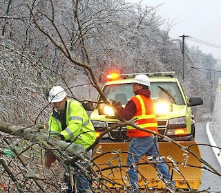
An ice storm that came up the east coast of the U.S., starting on Thursday December 11, 2008, hit hard those that live on and around US Route 20. Trees and branches were taken down by the heavy weight of the ice, causing large-scale power outages. Here is an except of one account of the storm in Massachusetts, from an AP press release:

A winter storm pounded New England with pouring rain, sleet and ice, knocking out power to hundreds of thousands across the region, closing schools and roads and prompting Massachusetts Gov. Deval Patrick to declare a statewide state of emergency Friday.

Georgine Sparr, the manager of Flynn's Truck Stop in Shrewsbury, said her customers in central Massachusetts complained of downed trees covered in ice and flooded roads from the storm that began Thursday and moved by late Friday morning.

She fielded dozens of calls from people who woke up in the dark and wanted to know if the Dunkin' Donuts inside the truck stop was open so they could get a warm cup of coffee.

"They got hit with everything at one time, except the snow, thank goodness," Sparr said. "The trees are frozen. Up and down Route 20, there's branches everywhere."


Here is a photo from the Worcester Telegram & Gazette showing some of the damage on one stretch of US Route 20 in Auburn MA:


The US Route 20 Blog homepage can be found here.

Monday, December 8, 2008

US20 in Montana: A Brief Ride


The longest road spends the shortest time in Montana, traveling only about 10 miles in a short finger of the state that juts between Wyoming and Idaho in the southwestern portion of the state. US Route 20 heads west into Montana from Wyoming and the west entrance of Yellowstone National Park. As it goes through the town of West Yellowstone, it is known as Yellowstone Avenue, Canyon Street, and Firehole Avenue. Continuing west toward Idaho, it is known as the Targhee Pass Highway. The Targhee Pass is on the continental divide, in the Henrys Lake Mountains.


The US Route 20 Blog homepage can be found here.
Saturday, November 29, 2008

US 20 in New York: Truck Protest in Skaneateles

Here is a news story about a truck protest, which took place on US Route 20 yesterday in Skaneateles, New York. US 20 is called Genesee Street in Skaneateles, and the city is on one of the Finger Lakes, west of Syracuse.


A video of the protest can be found here.

Parade of trucks draws big crowd
By Christopher Caskey / The Citizen Friday, November 28, 2008 11:44 PM EST

SKANEATELES - Hundreds of people lined Genesee Street in the village of Skaneateles early Friday afternoon to watch a parade. Some of them held signs, and some of them waved American flags. Many of them just stood on the sidewalk and gazed west, waiting to catch the first glimpse of the caravan.

The crowds descended upon Skaneateles to watch a parade of trucks rumble and honk along Route 20. The caravan was organized as a statement of protest against a proposed set of state regulations that would keep truckers from using certain rural, upstate routes as shortcuts.

Approximately 150 to 200 tractor trailers and diesel trucks drove in line from Waterloo through Skaneateles as part of the rally. The first trucks started rolling through the village at 12:45 p.m., and the parade lasted approximately 30 minutes.

The protest was staged on the same day as the kickoff for the Dickens Christmas, a village-wide festival that lasts through the holidays and is a popular event for both locals and out-of-towners.

Many of the spectators lining the street came in support of truckers, raising signs of encouragement and cheering as the drivers slowly ambled through town, one after another.

“It was a great sight to see when we came into the town,” Vincent Gramuglia, who has claimed to be one of the organizers, said after the rally. “I think it was a great success.”

Gramuglia is part of the Mohawk Valley Chapter of Truckers and Citizens United, the organization that staged the event. According to the group, the point of the rally was to protest regulations proposed by Governor David Paterson and the Department of Transportation to keep heavy trucks off of many rural roads.

The convoy proceeded along Route 20 for much of the way, though Route 20 is not restricted by the regulations. But many of the organizers have pointed to the village of Skaneateles as a symbol of anti-trucker sentiment.

Gramuglia clarified Friday that the organization does not have anything against the people of Skaneateles. It's the “small group of people” who are trying to dictate what goes on in the village, he said.

That “small group” is the Upstate New York Safety Coalition Task Force, a collection of regional residents and officials who rallied for the regulations. The coalition has contended that the trucks lessen the quality of life, wear down the region's infrastructure and create environmental hazards.

But truckers like Gramuglia say they are being unfairly targeted and that they have a right to use the public roads. The regulations would financially hurt the trucking industry, and that economic pain would pass onto consumers, Gramuglia said.

“We would like to try and sit down at a round table and and discuss this situation before it gets more out of hand,” said Gramuglia, who added that industry representatives are meeting with state officials next week in Albany to discuss the proposal.

David Card, of Skaneateles, also participated in the convoy. An owner of a trucking company himself, Card said it's time that people stop trying to take rights away from others.

People talk about keeping trucks on the Thruway, Card said. But if that happens, higher fuel costs and tolls will be more local and non-local companies can handle, he said.

“If we lose this, what's next?” asked Card, who said he knew of at least 25 or 30 local truckers who participated Friday. “These roads are paid for by people like myself.”

Spectators come to show support, concerns

While the day's main spectacle was the afternoon caravan, the streets were crowded by late morning. Some people formed clusters on corners and along sidewalks to claim a spot for watching the demonstration. Some meandered in and out of shops.

At noon, a crowd formed around the Sherwood Inn as the Dickens characters announced the start of the festival and sang Christmas carols.

Erica Leubaner, of Marietta, stood with a group of about 10 friends and family members to support the truckers' cause. As dairy farmers, Leubaner said her family depends on trucking in the area. Any rules that affect the trucking industry negatively will affect her family business in the same way, she said

Leubaner added that the first day of the Dickens festival was the perfect time to hold a rally.

“Any time people want to make a statement, they have to capitalize on a time when there's going to be a captive audience,” she said.

Skaneateles resident Jim Lanning was also there to support the truckers. He stood on the side of Genesee Street carrying a “Welcome” sign.

A truck driver himself, Lanning said local officials have been “harassing” local truckers for some time. This is ironic, he continued, considering all of the local merchants get their goods through commercial trucking.

“I think we can all get along together in harmony if we try,” Lanning said.

Not all the spectators were against the tighter restrictions, though. Skaneateles residents. J.D. and Darlene Lawson both raised signs imploring truckers to keep off routes 41 and 41 A.

The Lawsons live on Route 41, they said, and the trucks often come speeding down the road without much regard for the residents.

“That's a county road, not a state highway,” J.D. Lawson said.

He also said it was “disrespectful” of the trucking organization to hold the rally on the first day of the Dickens festival.

Skaneateles resident Bob Werner stood next to the road to watch the trucks. Events like these don't happen in the village every day, he said.

However, Werner said he understands the issues raised by local residents over the safety and environmental effects from heavy truck use in the area.

“Sometimes (the trucks) will tip over, and that can be a major concern,” Werner said.

Very few incidents, local officials say

Despite the large crowds and dissenting viewpoints, the trucks came and went with very few incidents. After the convoy passed through Skaneateles Police Chief Lloyd Perkins said that multiple New York State Police and Onondaga County Sheriff's officials were present in and around the village.

The truckers have a right to use the roads and a right to protest, Perkins said. The elevated force, he continued, was present to maintain public safety.

“I think it was very smooth,” sad Perkins. “I know that 99.9 percent of these truckers are great people.”

However, law enforcement did intervene a bit before the convoy reached Skaneateles. According to the state police, troopers in Auburn arrested John Cardinell, 69, of Weedsport and charged him with disorderly conduct and obstructing governmental administration.

Cardinell was one of the truckers in the convoy, according to the state police, though no police officials were available Friday evening for further comment.

State police in Auburn also gave out three other tickets when drivers stopped their rigs in the driving lanes and held up traffic.

After the event, Skaneateles Mayor Bob Green described the rally as a “peaceful” demonstration. Green said he hoped the increased foot traffic benefited local merchants and gave the village's annual holiday festivities some added publicity.

“I hope they feel like they accomplished something,” said Green, who noted that he thinks the truckers' issues should be taken up with officials in Albany, not Skaneateles.

“I do think their focus could have been better utilized finding solutions instead of spending a day and using fuel for a demonstration.”

An active participant in the Upstate New York Safety Coalition Task Force, Green said he expects the group to continue their efforts to restrict heavy truck traffic on rural, upstate routes.

In fact, coalition members met with officials in Albany two weeks ago to discuss the regulations, he said.

“After today's display, I think the coalition will become larger and louder,” Green said.


The US Route 20 Blog homepage can be found here.

Thursday, November 27, 2008

US 20 in New York: Vintage Diner Relocated

Here’s a story from the Schenectady Daily Gazette covering the relocation of a vintage diner to a location on US Route 20 at Route 406 in Princetown, NY. (Princetown is just east of Schenectady, NY.) Route 20 is called the Western Turnpike in that area. (If you click on the link to the Daily Gazette article, you can find a picture of the diner.)

Vintage diner to be operated at new location on Route 20
By Justin Mason Gazette Reporter


Crews used an industrial crane to hoist the 38-foot-long and 17-foot-wide structure onto a foundation off Route 20 Wednesday morning. They used a bar on top and cables beneath to suspend the forlorn-looking silver diner several feet in the air before effortlessly placing it on a pair of steel I-beams set into the concrete.

“It was just like a toy,” said owner Tom Ketchum, surveying the nearly 23-ton diner on its new base.

The diner car sat on blocks near Ketchum’s autobody repair shop for more than a year after it was hauled 630 miles from a warehouse in Michigan. Built by the Mountain View Diner Co. factory in New Jersey during the mid-1950s, the restaurant once served Champagne, Ill., where it was one of the early pioneers to sell Col. Harland Sanders’ legendary fried chicken.

Now, with the diner secured and all the necessary town approvals in hand, Ketchum and his wife Sally plan to continue the arduous task of restoring the eatery to its former grandeur. By next spring, they intend to open a full-service restaurant that will include authentic 1950s-era equipment and furnishings the couple has collected from across the nation.

This includes an authentic M-100 Seaburg jukebox Ketchum found in Detroit. He spent the past year restoring the player so it spins vinyl 45s as if it were new.

And consider the stainless steel foyer that once greeted customers when the diner operated in Champagne. Ketchum tracked down the dismantled pieces that had sat in storage since the last incarnation of the diner closed in 2002.

They acquired a pie case and ice cream parlor from the American Diner Museum in Rhode Island. Everything in the diner will be from the period when it flourished, Ketchum said.

“Everything in there will be real 1950s, not make-believe 1950s,” he said. “I sat on the Internet every day looking for what I wanted and what I could afford to buy.”

Ketchum even managed to track down the massive neon cowboy sign that stood outside the diner when it was first opened in 1956. When word about the diner’s revival spread, they were contacted by a former patron of the restaurant living in California, who offered the sign to them.

Ketchum said the woman had frequented the diner during college and purchased the sign as a memento when its original owners closed it in 1976. She initially intended to hang the sign in her West Coast art studio, but ended up stowing it in her mother’s garage in Illinois after learning it wouldn’t fit.

The authentic sign was oddly one of the holdups the Ketchums faced when seeking approvals from the Princetown Planning Commission. The 10-foot-by-8-foot sign far exceeded the allowed size in the town code.

Town officials were also slightly bewildered by the nature of the diner project. After all, Ketchum explained, it’s not often someone comes in with a project that includes a diner that’s already built.

“There are no plans for it,” he said. “This is an existing building.”

But after several months of meetings the town approved both the project and a zoning variance this fall, allowing the Ketchums to dig the foundation, move the diner and keep the sign. Now, he plans to complete an addition on the rear of the structure and finish renovating the original, including the neon sign, which he’s looking for help to restore.

The Ketchums have made a good deal of progress since the diner arrived last year. He’s restored some sections of the interior and all of the booths are now being reupholstered. Ketchum is also painstakingly removing rotted sections of wood beneath the stainless steel exterior.

“We didn’t dare do anything else until the diner was set,” he said.

Ketchum said moving the diner to its foundation is a large step in the right direction and one people are already starting to notice. Prior to the move, he said many people didn’t even realize he was doing work to restore the restaurant.

Several hours after the move, contractor Bob Frost poked his head in the diner to compliment the Ketchums on their progress. Earlier this month, he helped excavate for the foundation.

“It looks a lot better just sitting on the foundation,” he said.


The US Route 20 Blog homepage can be found here.

Sunday, November 23, 2008

US 20 In Ohio: The Dunham Tavern and Museum in Cleveland

Located on Euclid Avenue (US Route 20) in Cleveland, on the stretch between University Circle and downtown Cleveland, is the Dunham Tavern and Museum . It is the oldest building in Cleveland.

Built in 1824, it is a clapboard building that served as a stop along a stagecoach route between Detroit MI and Buffalo NY. At the time, the stretch of US 20, (now Euclid Avenue) midway between Doan's Corners (East 105th Street) and Public Square where Dunham’s was located was also known as part of the “Buffalo-Cleveland-Detroit Road.” The modern day Route 20 follows that same stagecoach route.

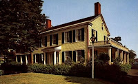
Dunham Tavern Postcard
Dunham Tavern was the home of Rufus and Jane Pratt Dunham, who were early settlers to the Western Reserve. As their home was along the stagecoach route, they decided to make their home a tavern, and it remained this way until 1857.

In the 1930s, the house was a studio for artists and printmakers, and later the Society of Collectors worked to restore the house, opening it to the public in 1941. It was named a Cleveland Landmark in 1973, and was added to the National Register of Historic Places on July 25, 1974.

Today, the museum is filled with many period antiques, and the Heritage Trail and gardens also make for a nice outdoor stroll and a peaceful respite from the surrounding industrial and urban neighborhood.

Dunham Tavern and Museum is located at 6709 Euclid Avenue (US Route 20) , in Cleveland, Ohio. More information can be found at the website for Dunham Tavern and Museum. .


The US Route 20 Blog homepage can be found here.

Monday, November 10, 2008

US 20 in Idaho: Craters of the Moon, Idaho Falls

To the left of the satellite photo the large basalt area of the Craters of the Moon National Park & Preserve are visible.
Idaho Falls is in the right of the photo.

After US Route 20 leaves Wyoming and the western end of Yellowstone National Park, it takes a southwestward trek through Idaho. The first major city that US Route 20 encounters after leaving Wyoming is Idaho Falls, Idaho. As US 20 approaches Idaho Falls from the north, it carries the names Rigby Highway. The City of Idaho Falls is the largest city in eastern Idaho, and the fourth largest city in the state. It serves as the county seat of Bonneville County. The city gets its name from the rapids and waterfalls on the Snake River.

According to Wikipedia:

“What became Idaho Falls was the site of Taylor’s Crossing, a timber frame bridge built across the Snake River. The bridge was built by Matt Taylor, a freighter, who, in 1865, built a toll bridge across a narrow black basaltic gorge of the river that succeeded a ferry nine miles upstream by a few years. Taylor’s bridge served the new tide of westward migration and travel in the region that followed the military suppression of Shoshone resistance at the Bear River Massacre near Preston, Idaho in 1863. The bridge improved travel for settlers moving north and west and for miners, freighters, and others seeking riches in the gold fields of central Idaho and western Montana. “


As US Route 20 turns west heading out of Idaho Falls, the name changes to West Broadway Street, and even father west, it becomes the West Arco Highway. As the road turns southwest of Arco, US20 runs concurrently with US 26 and US 93. Along this stretch of US20, and in the Snake River Plain, is the Craters of the Moon National Monument & Preserve.

This monument and preserve is one of the best preserved flood basalt areas in the continental United States. The landscape contains volcanic features including volcanic rifts, cinder cones, deep cracks, spatter cones, shield volcanoes and lava tubes.

The Monument was originally established on May 2, 1924, and in November 2000, the monument boundaries were expanded by President William J. Clinton by Presidential proclamation. It was officially designated as Craters of the Moon National Monument and Preserve in August 2002.

According to Wikipedia:

"The Monument and Preserve encompass three major lava fields and about 400 square miles (1,036 km2) of sagebrush steppe grasslands to cover a total area of 1,117 square miles (2,893 km2). All three lava fields lie along the Great Rift of Idaho, with some of the best examples of open rift cracks in the world, including the deepest known on Earth at 800 feet (240 m). There are excellent examples of almost every variety of basaltic lava as well as tree molds (cavities left by lava-incinerated trees), lava tubes (a type of cave), and many other volcanic features."


Further information on Idaho Falls and Craters of the Moon National Monument and Preserve can be found here:

The City of Idaho Falls
Wikipedia: Idaho Falls, Idaho

National Park Service, Craters of the Moon
Bureau of Land Management, Craters of the Moon
Wikipedia, Craters of the Moon National Monument and Preserve


The US Route 20 Blog homepage can be found here.

Thursday, October 30, 2008

US 20 In Ohio:Woodville, Lime Center of the World


As US Route 20 in western Ohio heads northwest towards Indiana, it goes through the small village of Woodville, Ohio, which is less than 20 miles southeast of Toledo, Ohio and a short distance from Lake Erie.

Odd that that city is called Woodville, because its claim to fame is that it is the lime center of the world. No, not the green citrus fruit that grows on trees, the lime that comes from limestone. A historical marker on US 20 – called East and West Main Street in Woodville – has the following inscription:

Woodville “The Lime Center of the World.”

Woodville and the surrounding area is situated in the center of a huge deposit of some of the purest dolomitic limestone in the world. The absence of cracks in the rock stratum and relatively level terrain in the area prevents the contamination of the limestone. In recent years, Ohio has ranked as high as first nationally in the production of lime, and fourth in the production of crushed stone. Demand for the lime and lime products as a building material led to the economic growth and development of Woodville.

Another historical marker in the area on US Route 20 designates the Maumee and Western Reserve Turnpike. The marker notes the following:

Maumee and Western Reserve Turnpike
The first road to traverse Sandusky County through the Black Swamp was little more than a muddy path connecting Lower Sandusky (Fremont) and Perrysburg with Woodville. The arduous task of clearing the 120-foot-wide road through the swampy forest was completed within four years. By 1842, the work of stoning the road and draining adjacent lands was completed. Tolls were collected to maintain the road, and it became known as the Maumee and Western Reserve Turnpike. After 1888 it became a toll-free road and today is U.S. Route 20.


But lime is key to the residents of Woodville, as the industry drives their economy and has helped the city to flourish. In fact, there is an annual Lime Festival in September that honors the stone.

According to the Toledo Blade, US Route 20 west of Woodville has been undergoing some extensive work to widen the roadway. The Blade stated back in July that “The 5 1/4-mile project is scheduled for completion by November, 2009. When it's finished, U.S. 20 will have at least four lanes from State Rt. 420 all the way to Fremont. The junction of U.S. 20 and State Rt. 420, which connects with I-280, was rebuilt into an interchange in an ODOT project that was completed last year.”

By the way, in case you were wondering, according to the Woodville web site, The Village of Woodville was named after Amos E. Wood, who, with George H. Price, platted it in 1836. Mr. Wood was later elected to Congress but died before his arrival in Washington.” So that's why it's called Woodville, and not "Limeville."


The US Route 20 Blog homepage can be found here.

Saturday, October 25, 2008

US 20 In Pennsylvania: Erie


US Route 20 doesn’t spend a lot of time in Pennsylvania, only running for about 50 miles through the top northwest corner of the state, between Ohio and New York states. US 20 hugs the shoreline of Lake Erie, just north of I-90, as it travels through Pennsylvania.

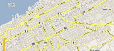
US 20 carries many names as it travels through the city of Erie. As it reaches the Erie city limits, it becomes West 26th Street, and after reaching the city center (at State Street), it becomes East 26th Street. With a brief northward turn at the Bayfront Connector, it is called Broad Street. With another eastward turn its name changes to Buffalo Road.

The city of Erie is named for Lake Erie and the Native American tribe that resided along its shore. As of the most recent census, it is Pennsylvania’s fourth largest city. Like many large “rust belt” cities close to Erie, (Cleveland, Ohio; Buffalo, New York; and Pittsburgh, Pennsylvania) it has an industrial past.

According to Wikipedia:.

The Six Nations of the Iroquois Confederacy and the Seneca Nation occupied the lands now known as Erie…The French built Fort Presque Isle near present day Erie in 1753, as part of their effort to garrison New France against the encroaching English. The French word "Presque-isle" means peninsula (literally "almost an island") and refers to that piece of land that juts into Lake Erie that is now called Presque Isle State Park. When the fort was abandoned by the French in 1760, it was their last post west of Niagara. The British occupied the fort at Presque Isle that same year, three years before the end of the Seven Years' War in 1763.

Present day Erie would have been situated in a disputed triangle of land that was claimed by the states of New York, Pennsylvania, Connecticut (as part of its Western Reserve), and Massachusetts. It officially became part of Pennsylvania on 3 March 1792, after Connecticut, Massachusetts, and New York released their claims to the federal government, which in turn sold the land to Pennsylvania for $151.6 million in Continental certificates. The Six Nations of the Iroquois Confederacy released the land to Pennsylvania in January 1789 for payments of $2,000 from Pennsylvania and $1,200 from the federal government. The Seneca Nation separately settled land claims against Pennsylvania in February 1791 for the sum of $800.


Erie may be best known for its massive lake effect snows which come in off Lake Erie. (Living east of Cleveland and west of Erie myself, I can confirm that lake effect snowfall is often measured in feet, not inches.) It is also well known for Presque Isle State Park , which receives millions of visitors each year.


Panorama photo of downtown Erie, 1912. Is US 20 in this picture? Can anyone confirm?


The US Route 20 Blog homepage can be found here.
Friday, October 17, 2008

US 20 in Ohio: RTA Healthline on Euclid Avenue

Last July, I wrote here about the Euclid Corridor Project , which was a complete reworking of US Route 20 (Euclid Avenue) in Cleveland, Ohio, from the Terminal Tower east to University Circle.

The work is done, and an official “grand opening” of the new and improved Euclid Avenue in downtown Cleveland will be held on October 24-25, 2008. American Idol winner Jordan Sparks will perform on October 25th at a concert in downtown Cleveland as part of the grand opening.

The corridor will also be christened with its new name, the RTA HealthLine. No, it’s not a phone number to call for medical information. It gets its new name from a partnership with the Cleveland Clinic and University Hospitals, and of course, Cleveland’s Regional Transit Authority.

The improvements to US route 20 include a special rapid transit vehicle (RTV) that will move passengers through 59 stops, beginning at Cleveland’s downtown Public Square and ending at University Circle. The vehicles will help make the ride a little “greener”, since they are powered with hybrid technology. All 59 stations are equipped with a fare vending machine, generous seating, and 24 hour lighting; 19 of the stations have an interactive kiosk to keep travelers informed and even entertained during their short wait. There were also 1,500 new trees planted on the route to beautify the area. Special bike lanes have also been added.


It’s interesting to note that the area where this new line runs is in the same area as where Cleveland’s Millionaire’s Row was once located. It was reported that the Euclid Corridor project itself cost $200 million for the 7.1-mile stretch of Euclid Avenue where the HealthLine will run.


For more information, check out the RTA HealthLine web site.


Here is an overview of the Euclid Corridor Project when it began.


The US Route 20 Blog homepage can be found here.

Thursday, October 9, 2008

US 20: More Route 20 in the Movies

There was so much press about Ang Lee’s movie “Taking Woodstock”. which recently did a lot of filming on US Route 20 in New Lebanon, NY that I thought I’d go back to see what other films may have been filmed on, or very close to, the country’s longest road.

One that seemed to jump out was the 2006 filming of “Spiderman 3” which had some scenes filmed in downtown Cleveland Ohio, which is only about 25 miles from my home. Route 20 (Euclid Avenue) acted as “stand in” for New York City for precision driving stunts, car crashes, smoke effects and other stunts. Someone was able to get some nice action shots of the filming, and you’ll find that video below.

One famous baseball movie was filmed near US 2o at a now famous location in Dyersville Iowa. That movie is “Field of Dreams” which starred Kevin Costner. The baseball field which was the movie site is still there and is open for tours. It’s very close to US 20 and just 25 miles west of Dubuque, Iowa.

The 1993 comedy “Housesitter” with Steve Martin and Goldie Hawn has a scene filmed at the Grist Mill on the grounds of the Wayside Inn on US 20 In Sudbury Massachusetts. A more recent film, the 2008 release “The Women” also had a scene shot on US 20 in Sudbury at the Bosse Sports & Health Club.

Another movie with some scenes filmed near US 20 was the Sci-fi film “Starship Troopers” which did some filming at Hells Half Acre in Powder River, Wyoming.

I am sure there are probably more movies out there that have been filmed on US Route 20, but it seems that information on this topic is scarce. If anyone would like to add a movie to the list, please feel free to add it to the comments below.


Spiderman 3 Filming Starring US Route 20 (Euclid Avenue, Downtown Cleveland)


The US Route 20 Blog homepage can be found here.

Saturday, September 27, 2008

US 20 in Ohio: Millionaire’s Row

Samuel Andrews Mansion


I just published an entry today in my blog, ”All Things Cleveland”, about Cleveland’s Millionaire’s Row, which I felt was also appropriate to share with fans of US Route 20. Millionaire’s Row was a stretch of US 20 (Euclid Avenue) in Cleveland where, in the later 1800s and early 1900s, some of the wealthiest people in the city and the nation took up residence. Mark Twain, in a 1868 letter, said about Euclid Avenue:

“Cleveland contains one of the finest streets in America -- Euclid avenue. Euclid is buried at one end of it -- the old original Euclid that invented the algebra, misfortune overtake him! It is devoted to dwelling-houses entirely and it costs you $100,000 to "come in." Therefore none of your poor white trash can live in that street. You have to be redolent of that odor of sanctity which comes with cash. The dwellings are very large, are often pretty pretentious in the matter of architecture, and the grassy and flowery "yards" they stand in are something marvellous -- being from one to three hundred feet front and nine hundred feet deep! -- a front on the avenue and another front on Lake Erie.”

Many rich industrialists lived on Euclid Avenue in Cleveland. The most notable was industrialist and philanthropist John D. Rockefeller. But Rockefeller made sure that his house was demolished after his death, preferring that to its eventual deterioration.

Due to over industrialization of the area and urban decay, only a few of the original mansions are still standing today.

One thing I didn’t include in my original blog entry was a link to a excerpt from a book “Showplace of America, Euclid Avenue 1850-1910” By Jan Cigliano which includes segments of the book which are available through Google Book Search. While the complete book isn’t online, there are many pages viewable which give a very interesting view, in both text and pictures, of how Euclid Avenue looked when lined with mansions. The book looks like a fitting tribute to a once grand stretch of the longest road in the United States.

If you’d like to see more information on Millionaire’s Row, check out the links below.


Additional reading
”All Things Cleveland: “Cleveland’s Bygone Millionaire’s Row” (includes links to pictures of some of the mansions and list of those still standing)

Euclid Avenue's Million-dollar Legacy

“Showplace of America, Euclid Avenue 1850-1910” By Jan Cigliano, book excerpts from Google Book Search


The US Route 20 Blog homepage can be found here.

Tuesday, September 16, 2008

US 20: "Taking Woodstock" Continues Filming on US20


I’ve been following the filming of the movie "Taking Woodsotck" by director Ang Lee, as quite a bit of the filming is being done on and around US Route 20 in New York. Here’s the latest update on filming on location; toward the end it discuses the most recent activities on US 20.

Stephentown gets star turn in Woodstock film
Producers of film about legendary show make use of several areas in town
By BOB GARDINIER, Staff writer
First published: Tuesday, September 16, 2008


STEPHENTOWN -- This rural town is going Hollywood as several locations are used to film the Ang Lee directed movie "Taking Woodstock" over the next few weeks.
On Monday a section of Route 43 was closed near Tinley Road for the filming of a scene depicting the famous traffic jam that occurred at the outset of the August 1969 rock festival in Bethel, Sullivan County.


Hundreds of extras dressed in tie-dyed clothing and loaded into period vehicles clogged a section of the state route near Calvin Cole Road Monday. They came to the site in tour buses to re-create the infamous Route 17B traffic jam that prompted concertgoers nearly 40 years ago to abandon their cars and hoof it to Max Yasgur's alfalfa fields at the junction of Hurd and West Shore roads just off the highway.

"The producers told us they had carried around a picture of the actual traffic jam and when they traveled that section of the road, they stopped in the middle of the road and said 'This is it,' " said Larry Eckhardt, town councilman and liaison between Tuxedo Terrace Films, the company shooting the movie, and town residents.

"They told us that the section of road looked just like Route 17B did in 1969," Eckhardt added.

The film is based on the memoirs of Eliot Tiber who, while managing the bar at the El Monaco Motel in the Catskills in 1969, played a key role in organizing the festival.

According to town officials who met with film producers in late August, they planned to have about 300 extras for the traffic jam scene along with vehicles from the '60s or earlier. The site was prepared and a rehearsal held Sunday, and clean up will be done today.

Eckhardt said later Monday that he had received no complaints from residents along the road. Though the road was closed to traffic most of the day, people who live along the stretch were got special placards to allow them access to their homes, Eckhardt said.

Representatives of the film company did not immediately return calls for comment Monday.

Filming will continue in town early next month when crews take over the old Stephentown Hotel. Work has already been done to make the hotel look like the El Monaco, which was owned by Tiber's parents. Discussions at the hotel bar in 1969 led to the staging of the rock festival.

Filming at the hotel is scheduled for Oct. 6 and 7.

On October 2 and 3, the Evangelical Community Church near the intersection of routes 22 and 43 will have a role in the film.

The church will become a church in Bethel where the Town Council had its meetings in 1969 with much discussion of the rock fest.

Production crews are also working in two fields in Schodack on School House Road off Route 20. One field near Route 20 resembles the large 'bowl' of the original Woodstock site. Workers Monday had rainmaking equipment at the site and a resident, who did not want to be named, said crews were filming the Woodstock mudhole scenes. It rained during the concert turning Yasgur's field into a muddy mess.


Here are the other entries from my US20 blog covering the film:

Taking Woodstock Set Pictures and Filming Information

Woodstock Movie Filming in New Lebanon

A “Taking Woodstock” Update


The US Route 20 Blog homepage can be found here.

Monday, September 15, 2008

US 20 In Iowa: The US 20 Corridor Association


Image from US 20 Corridor Association


The headline on the The US 20 Corridor Association’s web site says “Go Four It!” That’s because their work is to promote making US Route 20 to four lane service across the state. One goal is to relieve traffic pressures on I-80, which also cuts through the state. And it seems they want to do it right, by being cautious of historical and environmental concerns.

The US 20 Corridor Association’s web site is worth a visit for anyone interested in US 20, and shows they have a deep respect for the nation’s longest road. You can also find links to traffic information, pictures, news, and also a PDF document with their 2008-2012 plan. It’s a very comprehensive look at what is probably a very big undertaking.

Here’s an example of one of the articles written on the web site:

The US Highway 20 Northwest Iowa's Gateway to the World


US Highway 20 was one of the very first coast-to-coast highways in the United States. Starting in downtown Boston, it travels through Massachusetts, New York, Pennsylvania, Ohio, Indiana, Illinois, Iowa, Nebraska, Wyoming, Idaho, and Oregon.

US 20 is a direct route from Iowa's manufacturing and food processing industries to the northeastern United States, one of the world's largest and wealthiest markets. US Highway 20 is also a direct route for Iowa's exports to the seaports of the Northwest.

Manufactured products trucked out of northern Iowa include farm machinery, pre-molded counter tops, doors, lamb, turkey, ostrich, pork and beef products, groceries, boat trailers, model airplanes, pet food, rebuilt farm machinery parts, highway construction equipment, consumer dairy products, popcorn, food, furniture, home appliances, computers, truck trailers and bodies, hydraulics, baked goods, grain bins, park equipment, plastic products, home products, glass products, fishing tackle, manufactured homes, snow mobiles, personal water craft, building products, cattle feeders, paint, baseball caps, stained glass architectural products, utility trucks, veterinary and medical products, pharmaceuticals, flowers, recycled paper, plastic and steel, recycling equipment, commercial refrigeration equipment, barbecue sauce, cattle and hog equipment, packaging materials, grain products of various kinds, candy, genetics, ethanol, and a few dozen more.

50% of the millions and millions of bushels of corn and soybeans grown in the area are shipped out of northwest Iowa by truck according to estimates by the CC&P Railroad.

30 of the 109 Iowa companies employing 1000 or more people are located in or have a presence in the 10 counties of the US Highway 20 primary corridor including HyVee, IBP, UPS, Pioneer Hi-Bred, Wells Dairy, Gomaco, VT Industries, Midwest Independent Evapco, and Style Craft. All these are highway dependent companies.

6,645 business establishments are located in the 10 counties of the primary corridor of Highway 20.

11,153 businesses are located in the 19 counties that US 20 serves as an arterial highway feeding to and from I-29 and I-35.

US 20, soon to be completed to four lanes east of I-35, is the primary artery connecting with northwest Iowa' highway system. US Highways 169, 71, 59, and 75, State Highways 10, 18, 4, and 60, and multitude of secondary county roads feed to and from US 20. These primary roads serve the Iowa Great Lakes (Iowa's largest tourist area) and the thousands of businesses and farmers in the northwest part of our state.

US 20 is northwest Iowa's arterial link to the NAFTA main line and connects all North-South interstates in Iowa.

The US 20 route to Chicago from northwest Iowa is approximately 100 miles shorter than taking I-80. At an average trucking cost over a $1.00 per mile the savings per truck load in transportation alone amounts to more than $200.00 per round trip to Chicago and beyond.

Most of northwest Iowa is 60 to 90 miles from a four-lane highway. Today more than ever, one of the basic building blocks of economic growth is not just good transportation, but excellent transportation systems. Economic growth in northwest Iowa means increases in jobs, population, school enrollment, tax base, and the basic wealth of northwest Iowa's people. Economic growth means decreases in costs of welfare and crime.

The economy of northwest Iowa historically has been an important contributor to the state's economic well being. Continuing the economic growth of and turning around the population decline of northwest Iowa is important to the entire state.

The investment in bringing US Highway 20 to full four-lane service across the entire state is an issue of great economic importance to all of Iowa and certainly to the thousands of businesses and hundreds of communities in northwest Iowa.

The real economic benefit is long term. It is measured by lowered transportation cost of moving goods and services into and out of Iowa and by the opportunities for expansion of markets, increases in jobs and population for the entire northern half of Iowa.

Finishing US Highway 20 to a four-lane from Dubuque to Sioux City is a good investment for all of Iowa.


The US Route 20 Blog homepage can be found here.

Sunday, September 7, 2008

US 20 In Ohio: Geneva Swamp

Area near Rt 20 and Geneva Swamp (ignore shadow on satellite image)


The Cleveland Plain Dealer did a feature story today about a swampy area just north of US Route 20 in Geneva, Ohio (Ashtabula County), which is now part of the Cleveland Museum of Natural History. Why all the attention? Because the swamp is very representative of the way the city of Cleveland (Cuyahoga County) looked when Moses Cleaveland first settled in the area, long before US Route 20 (Euclid Avenue) was born. The geology of the area surrounding US Route 20 in the areas east of Cleveland in Lake County and Ashtabula County areas is very interesting. Much of US 20 runs along an old Lake Erie beach ridge (called the Lake Warren Ridge, after the larger, ancient Lake Warren that originally covered the area) that was formed as the glaciers retreated thousands of years ago. I live about ½ mile south of US Route 20 in Lake County, Ohio, and I can confirm that just looking at my own soil that this area had been a beach long ago.

In swampy Geneva land, museum sees Cleveland's history

Posted by Michael Scott September 07, 2008 02:50AM
The Cleveland Plain Dealer

Jim Bissell has this fantastical space-time machine. Really.

Here's how it works: You drive 50 miles east of Cleveland to Geneva, go about a half-mile past the train tracks north of town, turn left into a 400-acre bog and find yourself right back in Cleveland -- more than 200 years ago.

"This is time travel -- it really is," gushed Bissell, head of botany and natural areas for the Cleveland Museum of Natural History, which is gradually adding the swamp to its existing "collection" of thousands of acres across northern Ohio -- from Lorain through Ashtabula counties. "If you want to see what the mouth of the Cuyahoga looked like, come to Geneva swamp and look around.

"This is downtown Cleveland before the buildings."

Like the land discovered by Moses Cleaveland, this marshy area along Lake Erie was cut tens of thousands of years ago by glaciers that left behind sandy ridges and certain types of soil and plant life.

"The sand ridges are where they built roads -- like St. Clair or Route [U.S.] 20 or any number of others," Bissell said. "Did you know there were still frog ponds in downtown Cleveland in the 1930s and wetlands everywhere before they were drained?

"Well, they were there then, and it's kind of neat to see it all out here now -- just in a different place."

But the Geneva wetland is also home to a "globally rare beetle," Bissell said, and could be the "mother lode of interesting species."

For those reasons and more, Bissell believes the several-hundred-acre Geneva swamp is so valuable that he has committed hundreds of thousands of dollars in the last year to bid on portions of it for the museum. The first outright sale of a parcel is expected to close soon, museum officials said, and the others are in negotiations.

It's the same pattern he has followed for dozens of swamps, bogs and other wetlands in more than a half-dozen other northern Ohio counties over the last three decades.

Bissell, 61, became curator of botany at the museum in 1972 and began an aggressive -- but painstakingly patient -- effort to identify key areas in Ohio and Pennsylvania that he and others believed were vital wetlands worth preserving.

The museum's Natural Areas Program now has nearly three dozen nature preserves covering some 4,500 acres. About 1,500 more acres is pledged to the museum by property owners who still have title to their parcels.

"We'll be at 6,000 acres sooner than later if you add it all up," Bissell said.

It is believed to be the only municipal museum conservation effort of such scope in the country, experts have said. In all, the collection-outside-the-museum contains some 200 either rare or state-protected species: 110 plants and 90 fauna -- animals, bugs or other nonplant life.

The Geneva marshland, roughly 400 acres in all, is about three miles south of the Geneva State Park Lodge.

Bissell is negotiating with individual owners and paying for the parcels as he goes, relying on a $426,000 grant from the Kent Smith Charitable Foundation, an amount that must be matched by money raised from museum donors, he said.

Bissell and a handful of others -- both museum staff and volunteers with Northeast Ohio Naturalists, or NEON -- walked the Geneva swamplands one recent morning, cataloging plants, bugs and landforms.

Their constant banter and debate were strangely in harmony with chirping birds, humming cicadas and an intermittent squish-squish underfoot -- all punctuated by a train whistle on the hour.

Bissell said the diversity of an ecosystem, especially wetlands like this Geneva swamp, should be important to the average person for two reasons.

"Most of our pharmaceuticals come from plants, and all around us there is an arsenal of chemicals in these plants and some animals," he said. "Who really knows what the next one might be that helps humans."

The second reason?

"Because no one knows if you take out one species if it will be the one that leads to the unraveling of that ecosystem," said Stanley Stine, a part-time naturalist for the museum and the city of Twinsburg.

For that reason, the museum is involved "in not only acquiring land but in stewardship of the property afterward," Bissell said.

That's also part of the reason he keeps doing "any survey for free for anyone who asks for one." It's a way to find more biodiversity in the region but also a way to make more contacts for future property acquisitions.

"If Jim wasn't saving wetlands in Ohio and Pennsylvania, there wouldn't be wetlands being saved," said John Katko of Friends of Wetlands, another Bissell colleague and volunteer.

"People who own these types of lands know they look beautiful and maybe they like to walk it, but they don't really know everything that it contains," Stine said. "That's where we come in."


Museum preserves Geneva swamp


Jim Bissell will also be co-hosting a “Moss Hunt” at the Geneva Swamp for the Cleveland Natural History Museum on October 11, 2008. It is limited to 20 people, and more information can be found here.


The US Route 20 Blog homepage can be found here.

Monday, September 1, 2008

US 20: Follow "The Long Bike Back"

I wrote about the documentary film “The Long Bike Back” on May 5, here. The trip and film covers brothers Pearson and Peter Constantino, who are biking cross-country on US Route 20 to raise awareness of road safety. Their cross country trip on US Route 20 is in progress, and if you are interested, you can follow their trip on their blog, here, to get updates on their progress, and also see some photos of the areas where they are traveling.


The US Route 20 Blog homepage can be found here.

Friday, August 29, 2008

US 20 in NY: Taking Woodstock Set Pictures and Filming Information


The movie “Taking Woodstock” has been creating a lot of excitement on US Route 20 in New Lebanon, NY. (I’ve covered this on my blog here and here.)

A calendar of filming is being kept on the web site for the Town of New Lebanon, here. There is also a diagram of road closures, here.

There are also plenty of set photos that you can access at Onlocationvacations.com, here. They also have a nice write up about the filming:

Route 20 is one of the last great 2 lane highways, like Route 66 only in Upstate NY. And New Lebanon’s location is especially appealing because it is just a few miles from the Berkshires. Route 20 and the Berkshires offer plenty to do, antique shops, modern ruins, restaurants, and outdoor activities. It really is an interesting, beautiful part of the country!

In our first Taking Woodstock post we explained what the set was (an old motel set back off of Route 20) and what was around it (nothing). This post includes more pictures of them filming a scene in which an actor (who we recognize and can not place so if you know who he is please leave a comment and let us know) gets into his car outside of the motel. They also filmed exterior shots of just the motel from the road.

There were also a few old cars waiting for their close up so I am assuming they were filming more scenes later on. We didn’t see Demetri but we have seen on a few other blogs and message boards that he has been there.


The US Route 20 Blog homepage can be found here.

Saturday, August 23, 2008

US 20 in Ohio: A McDonald’s Demolition

And now for something completely different. Here are a two videos of a McDonald’s restaurant being demolished, located on US Route 20 (Mentor Avenue) in Mentor, Ohio. As nature abhors a vacuum, another bigger, better, and no doubt more calorie filled McDonald’s will be built in its place.

The McDonald’s is only 1.5 miles from the home of President James A. Garfield , a National Historic site and part of the National Park Service, and also located on US Route 20.


Part 1


Part 2


The US Route 20 Blog homepage can be found here.

Friday, August 22, 2008

US 20: A “Taking Woodstock” Update

I featured an article from the Berkshire Eagle on August 12 (here) about a movie – “Taking Woodstock” - being filmed on US Route 20 in New Lebanon, NY. Well, it looks like it’s been very good for the area, and it sounds like our favorite national road is getting a lot of attention. Here’s an update from the Berkshire Eagle:


'Woodstock' bolsters business

By Scott Stafford, Berkshire Eagle Staff
08/19/2008

NEW LEBANON , N.Y. — Mike DeBella is in the movie business.
He may never get a star on Hollywood Boulevard, but he is getting a much-needed boost to business at his Hitchin' Post restaurant.

Ever since crews came into town to start setting up to shoot the movie "Taking Woodstock," DeBella and his staff have been catering breakfast and sometimes lunch to the workers at the movie production staging facility down the road.

"We definitely got a good size increase," he said. "And they tell me that once they really start filming here in town, it's supposed be real busy. I may extend my hours depending on how that goes."

Workers for the film, which is being directed by Oscar-winner Ang Lee, have been living in campers and hotels around the area and eating in many of the local restaurants, such as DeBella's place, Bucky's Bagels and Shaker Mountain Barbeque.


Until now, much of the visible work has been in refitting the former Valley Rest Motel on Route 20 into a set for the film, a motel called Del Monaco. Inside and out, they will be using the motel for shooting scenes for the film, which is based on the book "Taking Woodstock" by Elliot Tiber.

Production offices are temporarily located in the former office of Ceramaseal, also on Route 20.

According to Colleen Teal, New Lebanon's town clerk, the film's planners started discussions with town officials in early spring, eventually

negotiating a temporary contract with the town that allows them to use a number of sites in a variety of ways without having to obtain land use or other permits that would normally be required.

Throughout the process, she added, officials with the production company, Tuxedo Terrace Films, have been "very proactive" about communicating with town officials, local businesses and community groups about what they'll be doing and what kind of disruptions or traffic they should expect.

The producer and screenwriter of the film, James Schamus, has a vested interest in making sure things go well, and that when filming wraps, there are no hard feelings. He is a resident of a nearby town in Columbia County.

"We always try to communicate with local people when we're working on a film, but I have an additional motive — that after this crew leaves town, I'm still going to be hanging around for 20 more years or so," Schamus said.

He also noted that New Lebanon townsfolk have been quite welcoming to the crew and patient with the difficulties the film might cause to everyday life.

"I've been involved in well over 100 films, and many times we don't have the situation we have here," Schamus said. "People have been extraordinary in accepting that there will be some disruptions. And people are actually communicating with each other about what's coming up — that is a big help."

"They give you a heads up about what to expect; they've been very good about that," DeBella said. "And they're always asking if we know local contractors or other businesses they need. They've been using a lot of local services."

For example, filming in New Lebanon should last four to five weeks, Teal said, and during September, scenes will be shot along Route 20 that will have to depict the monster traffic jam as concertgoers tried to reach the actual Woodstock concert. Filming those scenes will involve period cars and lots of extras. It is important that no contemporary vehicle wander into the shot, so Route 20 will be closed intermittently to allow the film crew to do its work.

"It's pretty apparent they know what they're doing and how to do it," Teal said. "And I think it's a wonderful thing for the town, especially the local businesses, in a year when the economy has had a downturn."

DeBella said the additional business couldn't have come at a better time.

"It was a tough winter, and this has gotten me caught up on a lot of bills," he said. "And hopefully, it will help me get through this winter."


An update and links to information on US 20 road closures for filming can be found here.

The US Route 20 Blog homepage can be found here.

Sunday, August 17, 2008

US 20: Cross Country on a Motorcycle

Here’s an interesting story from the Rochester Democrat and Chronicle that talks about a local couple who went cross country on US 20 by motorcycle. They didn’t go the whole route though; they started in Canandaigua. NY. Still, a significant ride!

Ontario couple uses motorcycle to follow Route 20

Ron and Evelyn Stone of Ontario, Wayne County, had a simple strategy for their trip west this summer:

Follow that road.

In their case, the road was Route 20, a highway that starts in Boston, Mass., and ends in Newport, Ore., near the Pacific Coast.

With Evelyn sitting behind him on his BMW motorcycle, an R 1200 ST, Ron picked up Route 20 on June 27 in Canandaigua.

On their trip, they left the mostly two-lane road occasionally, either to skirt cities or to take in an interesting sight, but generally they were true to 20 as they traveled more than 3,000 miles across the country.

Ron, 64, and Evelyn, 61, arrived in Oregon on July 6 and then left Route 20, heading south and then west to see their son, Mark, 36, and his wife, Rena, in New Mexico.

Coming home a faster route, mainly on interstates, they arrived in Ontario on July 19, having logged 7,500 miles.

That many miles, that many hours of close, wind-buffeted contact, might strain some relationships. But for the Stones, there's no better way to travel.

"I like the freedom a motorcycle brings," says Ron, who has been riding for more than 30 years. "You can smell the rain; you can smell the pines; you can smell the manure."

Evelyn, who left her BMW home for this trip, adds that not only do motorcyclists get to see the country in a more up-close-and-personal way, they also get to meet more people.

A bike is a conversational ice-breaker. People at restaurants and gas stations come up to the Stones, ask them where they're from, where they're going, where they've been.

This was the Stones' fourth cross-country trip, the last being a 2005 trek following Route 50, a road running from Ocean City, Md., to Sacramento, Calif., that's billed as "The Loneliest Highway in America."

On their treks, the Stones travel light, packing just enough clothes for seven days. On the seventh day, they take a break, do their laundry and rest. (On this trip, the first seventh day came in Cody, Wyo.)

The Stones ride between 300 and 400 miles a day, stopping about 5 p.m., as night rides on a motorcycle can be a little risky, given deer, buffalo (yes) and other creatures on the road.

They also allow for "wander time." Their favorite deviation from their route this time was a ride up and over Beartooth Pass in Montana and Wyoming.

But many sights along Route 20 — including lava flows in Craters of the Moon National Monument in Idaho — stopped them in their tracks.

"It's hard to explain how beautiful this country is," says Evelyn.

The Stones stay in motels, often filling up on the provided continental breakfasts and then skipping lunch. For dinner, they try to eat at non-chain restaurants, off-the-beaten path places. The food is generally good, and they get to meet the locals.

The motorcycle averages about 50 miles per gallon, so they don't spend a lot on gas, though they traveled this summer at a time when prices were nearing an all-time U.S. high. (The peak was $4.98 a gallon in California.)

They drove into a drought and experienced no significant rain on this trip. There was still snow in the Beartooth Mountains.

The temperature was 62 degrees as they rode through northern California and 118 degrees in southern California after they moved inland on their way to New Mexico.

The couple is looking forward to more long journeys, including a jaunt to Newfoundland with friends. And they hope to cross the U.S. on Route 30, another one of the vintage highways.

"So many roads, so little time," says Ron, whose motorcycling avocation is also vocation, as he works part-time as the sales manager at Country Rode Motowerks in Fairport.

He and Evelyn plan to give a seminar at Country Rode on their Route 20 trip later in the year. Meanwhile, Ron has this advice to anyone who would follow their path.

"Just go," he says. "Just make up your mind and go."


The US Route 20 Blog homepage can be found here.

Tuesday, August 12, 2008

US20 in NY: Woodstock Movie Filming in New Lebanon

Here’s an article from The Berkshire Eagle about a movie about Woodstock being filmed on Route 20 in New Lebanon, NY.

By the time they got to Woodstock
By Benning W. De La Mater, Berkshire Eagle Staff
Article Last Updated: 08/10/2008 12:19:02 PM EDT


NEW LEBANON, N.Y.
If you focus the lens in for a tighter view, you can see the signs. Rows of 1960s hippie clothes hang on racks inside an office building along Route 20.

Just down the pavement, dozens of 40-year-old Chryslers, Plymouths and Volkswagens — lots of Volkswagens — wait in a field behind Chuck's Automotive.

Construction crews revamp the Valley Rest Motel, a dingy, dying $59-a-night roadside stop.

Just one week out from the start of filming, work is under way on Oscar Award-winning director Ang Lee's newest movie "Taking Woodstock."

The bulk of the film will be shot at 14 locations across Columbia County. New Lebanon, a rural town of 2,400 known for its Shakers, dirt track season and mineral springs, is the epicenter of the production efforts.

Talk in these parts is building.

"People are ecstatic," said Kevin Fuerst, 48, the town historian. "There's definitely a buzz."

Lee, the mind behind "Brokeback Mountain," "Crouching Tiger, Hidden Dragon," and "Sense and Sensibility," was in town Wednesday scouting the locations, including the Valley Rest.

The movie is based on the book of the same name written by Elliot Tiber, a man who helped his aging parents operate a small motel in the Catskills and was influential in bringing Woodstock to Bethel, N.Y.

"The movie is about the preamble to Woodstock, and that's why I'm interested in the preamble to this movie," Fuerst said. "There's a lot going on around here ... a lot of logistics that are being considered."

For several weeks, construction crews have been working at the motel on Route 20, which the production crew is renting from a local businessman. They reconstructed a barn and built several new cabins on site. The old sign has been torn down, and "El Monaco Motel" is now painted in white letting on the roof. A 1950 blue Chevy pick-up sits out front.

Closer to town, Chuck Geraldi has been renting space at his auto shop for the crew to store period-era cars, like an orange Volkswagen Bug and a white 1960s police car.

"It's been interesting watching them," Geraldi said.

Outside of town, the production crew is renting space inside an old office building along Route 20. In the foyer, a "Brokeback" poster hangs on the wall, just down from a few black-and-white photos from the Woodstock event.

In a back room, a pink dress with white flowers clings tightly to a mannequin. Behind it, thousands of hippie outfits are lined up in rows.

Kay McMahon, president of the Lebanon Valley Business Association, said the movie has already boosted the local economy. Crews have been buying coffee and meals from area businesses and renting equipment from local stores.

"It's been great for businesses, and long-term, it will be fun to say that a movie was filmed in New Lebanon," McMahon said. "People are very excited."

McMahon said the movie team has been very cooperative with business and the town, a sentiment that town Supervisor Margaret Robertson seconded.

Route 20 will be closed intermittently during parts of September and October for filming. A public forum on the film will take place this Tuesday at the fire house in town to address any concerns citizens have.

Filming is set to begin on Aug. 17 and is expected to run 48 days. Some of the other sites include Cherry Plain State Park, a library in New Lebanon, and stops in Stephentown, Hillsdale and Millerton.

According to Variety's Web site, "Taking Woodstock" is being produced by Focus Features and will star Emile Hirsch ("Into the Wild"), Imelda Staunton ("Harry Potter"), Eugene Levy ("American Pie"), Dan Fogler ("The 25th Annual Putnam County Spelling Bee"), Jeffrey Dean Morgan ("Grey's Anatomy") and comedian Dimitri Martin.

The crew held tryouts in New York and Vermont in June and July for the thousands of extras that co-producer Michael Hausman said will be needed to play festivalgoers, townspeople and police officers.

James Schamus, Lee's writer on the film, lives in Columbia County and recommended that it be shot in the area because its landscape mirrors Max Yasgur's farm in Bethel, where close to 500,000 descended on the small town in August 1969 to hear bands like the Grateful Dead, The Who and Jimi Hendrix.

Fuerst said the minds behind the film chose well, as much of the small, rural towns in the county look similarly close to what they did in the 1960s and 70s.


Filming updates and links to information on US 20 road closures can be found here and here.

The US Route 20 Blog homepage can be found here.