Friday, November 13, 2009

US20 in Oregon: Pilot Butte


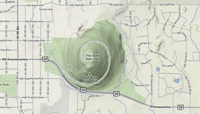
On the eastern side of Bend, Oregon, US Route 20 is called Greenwood Avenue. It runs at the southern side of Pilot Butte, which is an extinct volcanic cinder cone. According to Wikipedia, Bend is one of the very few cities in the United States with volcanoes located within their boundaries.


View from US 20

There are three trails that cover the state park. All lead to the summit, which provides a fantastic view of the surrounding area, including the city of Bend, and many prominent Cascade Mountain peaks. It sounds like another one of those scenic wonders that the longest road in the United States can bring!


View from the summit


Aerial View


Additional Information on Pilot Butte can be found here:


Wikipedia: Pilot Butte

Oregon State Parks: Pilot Butte

US Geological Survey Information on Pilot Butte


All Original Text Content © usroutetwenty.blogspot.com unless otherwise noted

The US Route 20 Blog homepage can be found at usroutetwenty.blogspot.com, here.

Friday, October 9, 2009

US20 In Ohio: Dangerous Intersections

US20/SR 306 Intersection (Google Street View)

When driving US Route 20, one can see some beautiful sights. But there is also a dangerous side to the nation’s longest road. A news story published today by the Cleveland Plain Dealer indicates that the intersection of US Route 20 (Mentor Avenue) and State Route 306 (Reynolds Road) in Mentor, Ohio (Lake County) is the second most dangerous intersection in the Greater Cleveland area. The rankings were compiled using the top crash locations between 2005-2007, in a report published by the Northeast Ohio Areawide Coordinating Agency in 2009. As Route 306 connects 2 freeways, I-90 and State Route 2, separating them by only a few miles, significant car and heavy truck traffic travels through the US 20 intersection, which lies midway between both freeways. The city of Mentor has already made improvements to the intersection based on the findings from this report, which wasn’t released until mid-2009.


In addition, US20 is also listed two other times on the list for dangerous intersections in the same county: US 20 and State Route 84 (Mentor) and US Route 20 and State Route 91 in Willoughby.


The chart showing the rankings can be found at this link for the Cleveland Plain Dealer.


The US Route 20 Blog homepage can be found at usroutetwenty.blogspot.com, here.

Thursday, September 10, 2009

US20 In Ohio: Cleveland’s Public Square

Public Square (Google Maps)

US Route 20 has a very prominent place in the city of Cleveland, Ohio. It is one of the key roads to and through Public Square, which is the center of the city of Cleveland and has its roots all the way back to the "Original Plan of the Town and Village of Cleaveland" (yes, it was originally spelled “Cleaveland”), prepared in 1796 by the Connecticut Land Company. While passing the Square on the south and east side, it is known as Euclid Avenue. On the north and west side of the Square, it runs concurrently with US Route 6 (AKA the Grand Army of the Republic Highway) and US Route 42, and is called Superior Avenue, and then later Detroit Avenue after it crosses the Cuyahoga River.


US 20 Euclid Ave. westbound into Public Square, the Terminal Tower and the Soldiers and Sailors Monument in view

Public Square, Old Stone Church in background (note the shadow of the Terminal Tower on the buildings to the left of the church) © chrisazimmer, used with permission


As it skirts Public Square, US 20 passes many landmarks, both old and new; The Old Stone Church, The Soldiers and Sailors Monument , and 200 Public Square are some examples. The Terminal Tower is on the Square itself, and US 20 passes only a few hundred feet from the entrance of Cleveland’s most famous landmark.

Old Postcard (undated) of Public Square with US 20 notations added


US 20 and base of 200 Public Square (Tower) (Google Earth)


All Original Text Content © usroutetwenty.blogspot.com unless otherwise noted

The US Route 20 Blog homepage can be found at usroutetwenty.blogspot.com, here.

Saturday, August 29, 2009

US20 in Ohio: Police Chase

And now for something completely different…Here is a video of a police chase (dashcam video) that took place in part on US Route 20 (Mentor Avenue/Euclid Avenue) in Willoughby Ohio.

The police chase began when police, driving on US20 Mentor Avenue eastbound over the Chagrin River bridge, saw the driver traveling at 65 mpg in a 35 mph zone. The police car turned around and headed westbound, towards the intersection where US20 changes from Mentor Avenue to Euclid Avenue. The police car turns left and begins to travel through downtown Willoughby (Euclid Ave.), veers off a few side streets temporality, and eventually turns right and gets back on US 20. The car stays on US20 for quite some time, until the police car makes a hard right on to US 91.

Enjoy the ride!

(If you can’t view the video here, it can also be located on the WKYC website at this link.)


The US Route 20 Blog homepage can be found usroutetwenty.blogspot.com, here.

Thursday, August 20, 2009

US20 In Iowa: Waterloo


US Route 20 passes through the southern side of Waterloo, Iowa. South and east of the city it connects with Interstate 380 and Iowa Highway 27, then crosses US Route 63 as US 20 continues to head west.

Wikipedia gives this information about the early days of Waterloo, Iowa and the naming of the city:


Waterloo was originally known as "Prairie Rapids Crossing". The town was established near two Meskwaki Native American villages alongside the Cedar River. It was first settled in 1845 when George and Mary Hanna and their children arrived on the east bank of the Red Cedar River (now just called the Cedar River). They were followed by the Virden and Mullan families in 1846. Evidence of these earliest families can still be found in the street names Hanna Blvd., Mullan Avenue and Virden Creek.

The name "Waterloo" supplanted the original name, "Prairie Rapids Crossing" shortly after Charles Mullan petitioned for a post office in the town. Since the signed petition did not include the name of the proposed post office location, Mullan was charged with selecting the name when he submitted the petition. Tradition has it that as he flipped through a list of other post offices in the United States, he came upon the name "Waterloo." The name struck his fancy, and on December 29, 1851, a post office was established under that name. The town was later called the same, and Mullan served as the first postmaster from December 29, 1851 until August 11, 1854.


Waterloo is also the county seat of Black Hawk County. It also is home to the Grout Museum District, which is a group of museums that include the Grout Museum of History & Science, the Bluedorn Science Imaginarium, the Snowden House, the Rensselaer Russell House Museum and the Sullivan Brothers Iowa Veterans Museum.


All Original Text Content © usroutetwenty.blogspot.com unless otherwise noted

The US Route 20 Blog homepage can be found usroutetwenty.blogspot.com, here.

Thursday, July 30, 2009

US20 In Ohio: Lawnfield, Revisited

My first full blog post here was covering Lawnfield, the home of the 20th President of the United State, James A. Garfield, which is located on US Route 20 in Mentor, Ohio.

Not only am I fortunate enough to live less than a half mile from US 20, I live less than two miles from Lawnfield, a National Historic Site. Since it was a beautiful summer day, I thought I’d take a quick drive to Lawnfield and get some updated pictures of the house and the grounds (I got there too early today and the house interior wasn’t open.) I saw something on the grounds that I did not see the last time I was there – it was an artist’s depiction of Garfield’s property and the area around it during the time of Garfield’s 1880 presidential campaign. It clearly shows US Route 20, which was - and still is - known as Mentor Avenue. (I’ve highlighted in with a large arrow on the photo below so it is easier to spot.)

To refresh everyone’s memory, here’s what I wrote in February 2008 about Garfield’s Lawnfield:

When Garfield was a Congressman, he purchased what was known as the Dickey Farm, which included a nine-room home that sat on 16o acres. Since the house was not large enough for his family, Garfield had additions built on to the original structure, bringing the size of the house to 20 rooms.

In 1880, Garfield became a candidate for the presidency. He used the front porch of his Mentor home for speeches. The name of the house – Lawnfield – was what all the visiting reporters named it because of the wide grassy lawn around the home. After Garfield’s assassination in 1881, his widow Lucretia added on the first presidential library and vault in the county, starting the trend of presidential libraries for subsequent presidents. The family stayed in the home until 1936, at which time the family gave the house and all its contents to the Western Reserve Historical Society. The house operated as a museum, and was designated as a National Historic Site in December 28, 1980. It is also part of the National Park System.

The home was given a $12.5 million restoration in the 1990s, at which time the home was restored to its original state colors of gray and scarlet. The interior of the home is filled with antique Victorian furniture, 80% of which belonged to the Garfield family. Wallpapers were also reproduced where photographs or samples were available.

One interesting structure on the grounds is a large windmill, constructed to replace an earlier windmill that was needed to pump and store water from a well. Lucretia was very involved in this project. The windmill had been taken down in 1936 due to wind damage. According to the Western Reserve Historical Society, “The structure was rebuilt after a generous and anonymous gift was donated for its reconstruction in 1998 and is standing once again in all its glory today.”


Artist's Depiction, Lawnfield and Mentor Avenue (US20) in 1880

Front of Lawnfield, with famous front porchWindmill at site entrance drive


Side view of house from site entrance


The Carriage House


The rear of the house


The campaign office

Back door

Historical Marker


All Content © usroutetwenty.blogspot.com unless otherwise noted

The US Route 20 Blog homepage can be found usroutetwenty.blogspot.com, here.

Sunday, July 12, 2009

US20 in Movies: Taking Woodstock (Trailer)

It’s been almost a year since I first reported that the movie ”Taking Woodstock” was being filmed on parts of US Route 20 in New York.

The movie is set to be released in the United States on August 28, 2009, with the country’s longest road serving as a backdrop.


More information on the film can be found on the official “Taking Woodstock” movie site, and the movie trailer is below.


The US Route 20 Blog homepage can be found usroutetwenty.blogspot.com, here.

Monday, June 29, 2009

US Route 20: "America’s Mainstreets" (video)

Here is a new documentary on US Route 20 (and also US Route 9) in New York, which was the result of a collaborative student project completed by undergraduate and graduate students Erin Dorbin (M.A. History and Media), Eric LaGrange (M.A. Fine Arts), Dale Mattison and Greg Pruden at the University at Albany in the Spring of 2009.

This documentary (video below) covers the history of US Routes 20 and 9 in New York, showing how the birth of freeways and thruways not only changed travel pattersn, but also changed the landscape of the US routes. This video represents the first edit of 22 minutes of their work.

More information about the video can be found at twojerks.blogspot.com. That web site indicates that “Erin Dorbin and Eric LaGrange are responsible for the completion of the Route 20 portion of the project, while Dale Mattison and Greg Pruden completed the Route 9/Frontier Town section of the documentary. Erin and Eric also have plans to continue the Route 20 portion of the documentary over the coming year.”

I found this video very interesting, and not just for the US 20 in NY perspective. Where I live – in Mentor Ohio – US 20 is very vibrant throughout my city and county (Lake County), along with neighboring Cuyahoga County (including the city of Cleveland) and Lorain County. This is despite the fact that two major freeways, US 90 and Ohio Route 2, run just about parallel to US 20, and sometimes only a mile away from US 20. Here, the freeways only helped US 20 to thrive. I consider myself very lucky to have US 20 remain an active, major thoroughfare here.


The US Route 20 Blog homepage can be found usroutetwenty.blogspot.com, here.

Friday, June 19, 2009

US20 In Wyoming: Casper


US Route 20 heads into Casper Wyoming, following both a “business” route, and also a “bypass” route. The business route heads directly into the city and is also known as the Yellowstone Highway, and as First Street in the heart of the city. It travels concurrent with the business routes for Routes 26 and 87. The bypass route is on the northern end of Casper and runs concurrent with bypass Routes 26 and 87, and I-25 as it skirts the city.

Casper sits at the foot of Casper Mountain, in the Laramie Mountain Range, with the North Platte River flowing around the city. It is the second largest city in Wyoming.

The city began as a frontier outpost called Fort Caspar, which was built during the mid-19th century to protect both mail and telegraph services. The city itself was founded long after the fort closed, and served as a railway stopping point. The city’s oil boom which started in the 1890s earned it the nickname ‘The Oil City.”

More information about the city can be found here:

The City of Casper

Casper Wyomomg Info Web Site

Casper Wyoming: A Great Place to Live - Video


All Original Text Content © usroutetwenty.blogspot.com unless otherwise noted


The US Route 20 Blog homepage can be found usroutetwenty.blogspot.com, here.

Saturday, May 30, 2009

US20: Twenty West Videos

Just about a year ago I wrote here about a book written by Mac Nelson called “Twenty West” which covered his cross-country trip on US Route 20. I just recently uncovered the following videos on YouTube that are from a short film where Mac Nelson talks about this trip and US Route 20. Here are the videos! (Note: some of the videos have the audio and video slightly out of synch.)


20 West Part 1


20 West Part 2


All Original Text Content
© usroutetwenty.blogspot.com unless otherwise noted

The US Route 20 Blog homepage can be found usroutetwenty.blogspot.com, here.

Thursday, May 14, 2009

US20 In Wyoming: Greybull

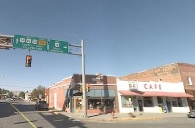
Intersection of US 20, US 16 and US 14 at Greybull, Wyoming

A few years ago, when my husband and I drove to Yellowstone National Park, we drove via a route that took us through Shell Canyon. We came out of the canyon on some sort of rudimentary dirt road that certainly did not look like it was supposed to be a dirt road on our map. Thankfully the road was dry and we had four-wheel drive. When we reached near the end of the dirt road, we found ourselves in the town of Greybull, Wyoming , in Big Horn County. We stopped at a small restaurant (I forget the name) on what looked like their main intersection. We were surprised to see that it was US Route 14 converging with US Route 16 and US Route 20 . It was then that we realized that we could have taken US Route 20, which is only a quarter of a mile away from my home in Ohio, and driven all the way to Yellowstone.


Route 20, as it converges with these other two routes, is known as 6th Street, specifically North 6th and South 6th as it intersects with Greybull Avenue (US Route 14).

The town may have received its name from a legend of an ancient albino buffalo believed to be sacred by early area Native Americans. In the early 1900s a railroad through the area helped connect it with Cody, Wyoming and with southern Montana, and the railroad helped the town to flourish. The town celebrated its centennial in July 0f 2006.

Greybull itself is not a major destination, but it is very close by to some great geological sights and points of interest: The Big Horn Mountains, Shell Canyon (to its east) Chimney Rock, Sheep Mountain, Devil’s Kitchen, and the Red Gulch Dinosaur Tracksite. There are also areas nearby for hunting and fishing.

If you’re planning a drive to Yellowstone National Park, whether you are going on US Route 20 or not, a stop in the Greybull area is worth your time. (Hopefully the dirt road is gone by now.) If you want to read more about Greybull, check out this on line book about Greybull, Wyoming.


All Original Text Content © usroutetwenty.blogspot.com unless otherwise noted


The US Route 20 Blog homepage can be found usroutetwenty.blogspot.com, here.
Thursday, April 16, 2009

US20 In Nebraska: Bridges to Buttes Byway

As US Route 20 heads westward in Nebraska, there is a 197-mile stretch between Valentine Nebraska and the border of Wyoming that is called the “Bridges to Buttes Byway.” This drive includes various terrains, from rolling sand hills, prairies, pine bluffs, and plateaus.

The Sandhills are on the eastern end, and this is the largest grass-covered stabilized sand dune formation in the Western Hemisphere. The area is ideal for ranching. As US 20 moves west, the topography changes to valleys and pine bluffs and buttes, which includes the Nebraska National Forest. Farther west is a large prairie at the Oglala National Grassland, and the Agate Fossil Beds National Monument.

There is so much to see and experience in this stretch of US Route 20. Here are two short videos that highlight some of the beauty of the Nebraska’s Bridges to Buttes Byway.


Bridges to Buttes By Way 2009 Podcast


Bridges and Buttes Byway Info Video


All Original Text Content © usroutetwenty.blogspot.com unless otherwise noted

The US Route 20 Blog homepage can be found at usroutetwenty.blogspot.com, here.

Monday, March 30, 2009

US20 In Ohio: Fremont, Home Of A President

In the north western area of Ohio, US Route 20 runs through the city of Fremont, the county seat for Sandusky County. As US 20 approaches from the east, it circles the city on the northern side via a bypass; however, it still technically runs through town as State Route 20 (State Street). The bypass is also named the “Grand Army of the Republic Highway), and it crosses the Sandusky River.
Not too far from where US20 runs through and around downtown Fremont is The Rutherford B. Hayes Presidential Center. Hayes was the 19th President of the United States. The Center is on 25 acres of wooded land that was originally a part of Hayes’ estate; Hayes named the area Spiegel Grove. The 31 room Victorian home of Hayes and his wife Lucy Webb Hayes which is on the property is open to visitors. This is where they retired after Hayes’ presidency concluded. The house still contains much of the family’s original furnishings from that era. Hayes and his wife are buried at a memorial on the property.

Also part of the The Rutherford B. Hayes Presidential Center is the Hayes’ Presidential Library. This was created and opened in 1916, long before President Franklin Delano Roosevelt established a formal system for presidential libraries, but Hayes’ library is considered the first.

The site was designated as a National Historic Landmark in 1964, and in 1966 was added to the National Register of Historic Places.


All Original Text Content © usroutetwenty.blogspot.com unless otherwise noted


The US Route 20 Blog homepage can be found usroutetwenty.blogspot.com, here.

Monday, March 16, 2009

US20: Travel Via YouTube

I compiled a list of all the videos I could find on YouTube that feature US Route 20. I found several, some professionally done, some very amateur (with lots of shaky cam). The videos from Mohawk Valley (NY) Living are very well done and they really make me want to check out that area. Enjoy!


Mohawk Valley Living #170 Route 20 (part 1 of 2)


Mohawk Valley Living #170 Route 20 (part 2 of 2)


Mohawk Valley Living #118 Road Trip along Route 20


Mohawk Valley Living #120 Route 20, Cherry Valley (1 of 2)


US 20 - Schoharie County, NY


US Route 20 - Charlton, Massachusetts


US Route 20 West to Westfield, MA


US 20 Dubuque – Over the Mississippi


The US Route 20 Blog homepage can be found at usroutetwenty.blogspot.com, here.

Monday, March 9, 2009

US20 In Oregon: Road Improvements

The Oregonian says that a stalled project for improvements to a stretch of US Route 20 in Oregon is now moving forward. In an article titled ” U.S. 20 gets a boost” they give some details:


The project: In 2006, the Oregon Department of Transportation and contractor Granite Construction began a $150 million project to straighten a treacherous 10-mile section of U.S. 20 between Pioneer Mountain and Eddyville, a popular route to the coast.

The new stretch would shave four miles off the current drive, open the road to 53-foot semitrailers -- currently not permitted on the tight curves -- and be expected to reduce the accident rate.

What happened: In 2007, the project came to a halt after the state Department of Environmental Quality fined ODOT $90,000 and Granite Construction, doing business as Yaquina River Constructors, $240,000 for water quality violations involving erosion that damaged salmon spawning grounds in the Yaquina River and its tributaries.

After nearly a year of negotiations, ODOT and Granite agreed on a plan to stabilize ancient landslides. Workers returned to the job last spring, setting a new completion date of late 2011.

What's new: The Oregon State Transportation Commission added $13.8 million in federal stimulus money to the project. The extra cash will allow ODOT to make improvements on curves at the west end of the project that it originally had tabled because the repairs were too expensive.

"It would not have been fully up to standard," said Vivian Payne, ODOT Area 4 manager. "This additional money allows us to make those curve improvements the right way."

It is also more environmentally friendly, Payne said, because they will replace a culvert with a bridge. "In the long run, it will be a better highway for users as well as a better environmental solution for fish and other resources."


The full article, ” U.S. 20 gets a boost” can be found here.


The US Route 20 Blog homepage can be found at usroutetwenty.blogspot.com, here.

Thursday, February 26, 2009

US 20 Cross Country Motorcycle Trip

I stumbled upon a blog, called "Jim and Nate Do America" which outlines a motorcycle cross-country trip on US Route 20 in the summer of 2008. They provide a detailed map of their trip (embedded below) and also include a photo slideshow on their blog of pictures taken on their trip, with a day by day accounting of their experiences.

If you’re looking for something to read about the country’s longest road from the perspective of someone who took the long drive all the way from end to end on a motorcycle, "Jim and Nate Do America" is an entertaining read.


View Larger Map

The US Route 20 Blog homepage can be found here.

Monday, February 9, 2009

US20 in New York: Promoting Travel on Scenic US20

If you plan on traveling on US Route 20 in New York State, you may want to check out NYroute20.com.The web site is maintained by the Route 20 Association of New York State, and highlights the Scenic Byway stretch of US20 between Duanesburg in the east, to LaFayette in the west.

The web site offers a brief history of the roadway in the state, and it also includes information on all kinds of activities along the way, like places to eat, lodging, attractions and special events. The site also includes a detailed map of the area .

If you are planning a trip on US20 in this area, NYroute20.com would be a great resource to help plan your trip. It’s nice to see an area take such an interest in promoting their section of the longest road in the United States!


The US Route 20 Blog homepage can be found here.

Monday, January 26, 2009

US 20 In Nebraska: Fort Robinson State Park


Sitting in the northwest corner of Nebraska, about three miles west of Crawford Nebraska along US Route 20 is Fort Robinson State Park. It began in 1874 as a military outpost, serving as a temporary cantonment during the turmoil of the frontier Indian Wars, and continued to serve as an outpost until shortly after World War II. During this time and afterwards, it continued to expand in area, eventually becoming one of the largest military installations on the northern Plains. It is known for being the site of the 1879 Cheyenne Outbreak, and for the death of famed Sioux Chief Crazy Horse.


The area now serves as one of Nebraska’s best state parks, covering 22,00 acres. There are plenty of outdoor activities for everyone to enjoy: hiking, camping, horseback riding, train and stagecoach rides, and fishing, plus many other outdoor activities. There is also a lodge, along with some cabins, for those not wanting to “rough it” outdoors.

The park also includes the Fort Robinson Museum which is operated by the State Historical Society which covers the rich history of the fort. The Trailside Museum of Natural History,which is operated by the University of Nebraska, explains the geology and natural history of the region.


Links for Further Information:

Fort Robinson State Park

The Trailside Museum of Natural History

The Fort Robinson Museum


The US Route 20 Blog homepage can be found here.

Tuesday, January 13, 2009

US20 In Illinois: Elgin May Rename to Honor MLK Jr.

Here’s a story about the work of one woman to get a stretch of US Route 20 in Elgin, Illinois renamed to honor Dr. Martin Luther King, Jr.


US 20 may be named for MLK Jr. in Elgin
January 13, 2009
By STEVEN ROSS JOHNSON

ELGIN -- What began as one resident's proposal to honor the contribution of Dr. Martin Luther King Jr. is now in the hands of state lawmakers.

It was about one year ago when longtime resident and city Human Relations Commissioner Ina R. Dews first proposed renaming a street after the civil rights leader.

The idea was picked up by area leaders, who spoke out last January in favor of designating a street after King, but little was heard about the matter in the months that followed.

In April, state Rep. Ruth Munson, R-Elgin, submitted a resolution to rename Route 20, currently known as the Ulysses S. Grant Memorial Highway, as Martin Luther King Memorial Highway, a stretch of road that runs from Shales Parkway to the border of Pingree Grove near Rein­king Road.

She said Monday the legislation is expected to be read today before the House of Representatives, where it likely will come to a vote.

If passed, Munson said it would be up to the Illinois Department of Transportation to provide the signage indicating the name change.

She said the movement of the resolution was to have it passed in time for the upcoming Martin Luther King Day celebration, scheduled for Monday, Jan. 19.

"Of course that was always a factor in trying to move the legislation along so that this weekend, it could be at least announced," she said.

The Federal Highway Administration has estimated hundreds of cities across the country have named streets after King. In 1968, Chicago became the first with the designation of a Martin Luther King Drive on the city's South Side.

City Manager Olufemi Folarin said Monday the decision to rename a state-run road as opposed to a city street came down to logistics.

"It's much easier to do that because you don't have businesses with a Route 20 address," he said. "So you'll won't inconvenience residents and businesses by having them change their addresses and spend money for new stationery and those kind of things."

The resolution is one of Munson's final acts as one of the area's state representatives, a position she has held since 2002, when she was first appointed to the seat after the death of Doug Hoeft who died in office. Munson won re-election in 2004 and 2006, but lost her seat to incoming state Rep. Keith Farnham last November.


The US Route 20 Blog homepage can be found here.

Friday, January 9, 2009

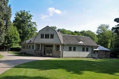
US20 In Wyoming: The Buffalo Bill Historical Center in Cody

If your driving to Yellowstone National Park from the east, US Route 20 goes through the city of Cody, Wyoming. And Cody, Wyoming is synonymous with William Frederick “Buffalo Bill” Cody, probably the most famous figure from the old American West .

The town was named for him when it was founded in 1896. After all, he did help found the city. So it’s also fitting that the town be the location for The Buffalo Bill Historical Center and Museum which gives a history not only of Buffalo Bill, but life in the American West. The museum also says:

"The collections of the Buffalo Bill Museum interpret the history of the American cowboy, dude ranching, Western conservation, frontier entrepreneurship and, perhaps most importantly, the source of our concepts about the West. The museum records how Buffalo Bill, in an age without television or motion pictures, became the world's foremost communicator about the American West. "

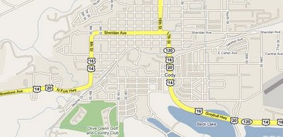
The Historical Center is located on US Route 20, which is called Sheridan Avenue in that area, running concurrently with US 16 and US 14. The Center is really a group of museums:

The Buffalo Bill Museum
The Whitney Gallery of Western Art
The Plains Indian Museum
The Cody Firearms Museum
The Draper Museum of Natural History
The Harold McCracken Research Library

If you're on US 20 coming from the east and headed to Yellowstone, make a point to spend some time in Cody and at the historical center/museum. It is an interesting slice of American history that shouldn't be missed.


Further Reference:


The US Route 20 Blog homepage can be found here.